ملف:Dryline front symbol.png
لا توجد دقة أعلى متوفرة.
Dryline_front_symbol.png (193 × 209 بكسل حجم الملف: 6 كيلوبايت، نوع MIME: image/png)
وصف قصير
| ⧼wm-license-information-description⧽ |
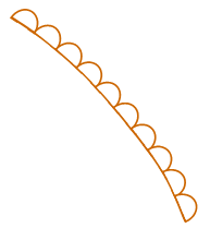
Français : Le front de point de rosée est une frontière séparant les masses d'air humides et sèches. Il se trouve généralement du nord au sud à travers les hautes plaines du centre et du sud aux États-Unis au printemps et au début de l'été, où il sépare l'air humide du golfe du Mexique (à l'est) et l'air sec du désert des États du sud-ouest (à l'ouest).
English: Dry Line - a boundary separating moist and dry air masses. It typically lies north-south across the central and southern high US Plains states during the spring and early summer, where it separates moist air from the Gulf of Mexico (to the east) and dry desert air from the southwestern states (to the west).
|
| ⧼wm-license-information-date⧽ | 2021 |
| ⧼wm-license-information-source⧽ | https://www.wpc.ncep.noaa.gov/html/fntcodes2.shtml |
| ⧼wm-license-information-author⧽ | Weather Prediction center of the US National Weather Service |
ترخيص

|
تاريخ الملف
اضغط على زمن/تاريخ لرؤية الملف كما بدا في هذا الزمن.
| زمن/تاريخ | صورة مصغرة | الأبعاد | مستخدم | تعليق | |
|---|---|---|---|---|---|
| حالي | ★ مراجعة معتمدة 07:28، 18 نوفمبر 2023 | | 193 × 209 (6 كيلوبايت) | Pastakhov (نقاش | مساهمات) | Upload https://upload.wikimedia.org/wikipedia/commons/8/84/Dryline_front_symbol.png |
لا يمكنك استبدال هذا الملف.
وصلات
لا يوجد صفحات تصل لهذه الصورة.