ملف:Chicago Central and Illinois Central route map 1996.png
حجم هذه المعاينة: 330 × 599 بكسل. البعد الآخر: 588 × 1٬068 بكسل.
الملف الأصلي (588 × 1٬068 بكسل حجم الملف: 174 كيلوبايت، نوع MIME: image/png)
وصف قصير
| ⧼wm-license-information-description⧽ |
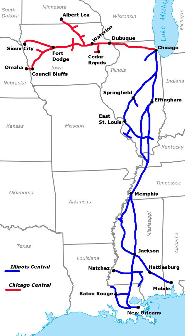
Combined route map of the Chicago Central Railroad (red) and Illinois Central Railroad (blue) as they existed in 1996. Map by Sean Lamb (User:Slambo), January 14, 2006. State outlines and water feature names cropped from Image:US_state_outline_map.png, routes, city dots, city and state names added with the GIMP. |
| ⧼wm-license-information-date⧽ | قالب:Original upload date |
| ⧼wm-license-information-source⧽ | No machine-readable source provided. Own work assumed (based on copyright claims). |
| ⧼wm-license-information-author⧽ | No machine-readable author provided. Slambo assumed (based on copyright claims). |
References
- Illinois Central Railroad (1997), Illinois Central Corporation 1996 Annual Report.
ترخيص
تاريخ الملف
اضغط على زمن/تاريخ لرؤية الملف كما بدا في هذا الزمن.
| زمن/تاريخ | صورة مصغرة | الأبعاد | مستخدم | تعليق | |
|---|---|---|---|---|---|
| حالي | ★ مراجعة معتمدة 06:01، 23 نوفمبر 2023 | | 588 × 1٬068 (174 كيلوبايت) | Pastakhov (نقاش | مساهمات) | Upload https://upload.wikimedia.org/wikipedia/commons/c/c9/Chicago_Central_and_Illinois_Central_route_map_1996.png |
لا يمكنك استبدال هذا الملف.
وصلات
لا يوجد صفحات تصل لهذه الصورة.