ملف:Chemin du Roy Repentigny Quebec.png
حجم هذه المعاينة: 800 × 559 بكسل. البعد الآخر: 933 × 652 بكسل.
الملف الأصلي (933 × 652 بكسل حجم الملف: 855 كيلوبايت، نوع MIME: image/png)
وصف قصير
| ⧼wm-license-information-description⧽ |
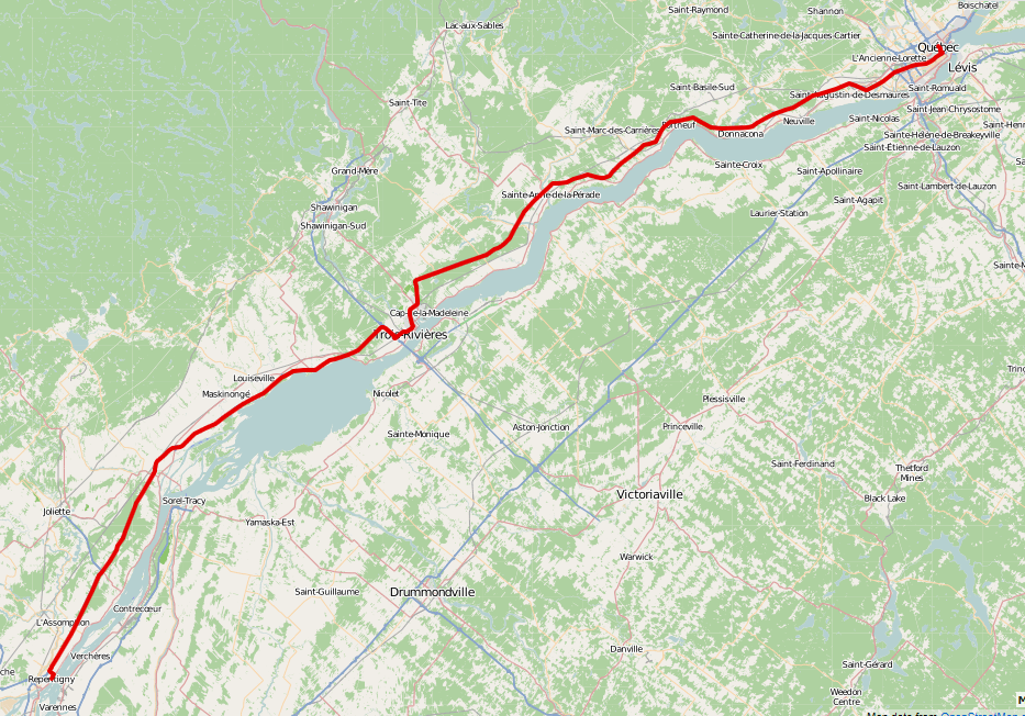
English: Map showing the route of the Chemin du Roy, from Repentigny towards Quebec City. The road extends almost 280 kilometres (170 mi). Actually a map following Route 138, which closely follows the Chemin du Roy for most of its route (not an actual Chemin du Roy trace, but almost nearly so).
Created using Open Street Map data from http://map.project-osrm.org/ to create a.gpx file. Then uploaded it to http://www.gpsvisualizer.com and created the map above with an Open Street Map overlay. All the data was generated using OSM data, allowing re-use.Français : Carte montrant le parcours du Chemin du Roy de Repentigny vers Quebec. En réalité, un parcours suivant la Route 138, qui suit de près le parcours du Chemin du Roy.
|
| ⧼wm-license-information-date⧽ | 2014, {{time}} – invalid date format 10 (help) |
| ⧼wm-license-information-source⧽ | ⧼Wm-license-own-work⧽ |
| ⧼wm-license-information-author⧽ | Oaktree b |
ترخيص
تاريخ الملف
اضغط على زمن/تاريخ لرؤية الملف كما بدا في هذا الزمن.
| زمن/تاريخ | صورة مصغرة | الأبعاد | مستخدم | تعليق | |
|---|---|---|---|---|---|
| حالي | ★ مراجعة معتمدة 21:29، 24 أكتوبر 2023 | | 933 × 652 (855 كيلوبايت) | Pastakhov (نقاش | مساهمات) | Upload https://upload.wikimedia.org/wikipedia/commons/d/d0/Chemin_du_Roy_Repentigny_Quebec.png |
لا يمكنك استبدال هذا الملف.
وصلات
لا يوجد صفحات تصل لهذه الصورة.