ملف:COVID-19 Outbreak Cases in Norway by municipalities.png

حجم هذه المعاينة: 423 × 599 بكسل. البعد الآخر: 2٬000 × 2٬831 بكسل.
الملف الأصلي (2٬000 × 2٬831 بكسل حجم الملف: 570 كيلوبايت، نوع MIME: image/png)

|
[All images in this gallery should be recreated using vector graphics as an SVG file. This has several advantages; see Commons:Media for cleanup for more information. If an SVG form of this image is already available, please upload it. After uploading an SVG, replace this template with {{vector version available|new image name.svg}}.] Error: {{Lang}}: text has italic markup (help) |
|
العربية | български | català | čeština | dansk | Deutsch | English | Esperanto | español | français | galego | 한국어 | italiano | magyar | lietuvių | 日本語 | Plattdüütsch | Nederlands | norsk | polski | português | română | русский | suomi | svenska | Türkçe | українська | 中文(繁體) | 中文(简体) | +/− | |
وصف قصير
| ⧼wm-license-information-description⧽ |
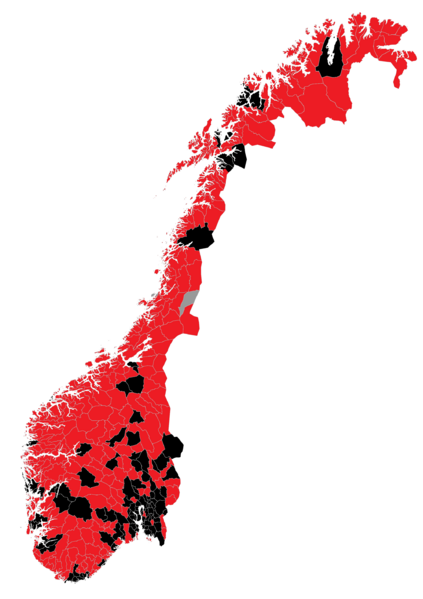
English: Map of the COVID-19 outbreak in Norway as of September 2021. Municipalities with confirmed cases marked in red. Be aware that since this is a rapidly evolving situation, new cases may not be immediately represented visually. Refer to the primary article 2020-22 coronavirus outbreak in Europe or the World Health Organization's situation reports for most recent reported case information. NOTE: Municipality borders are from before the regional reform of 1 January 2020. Source of infected municipalities: Live: Corona-viruset sprer seg i Norge og Verden by VG
|
| ⧼wm-license-information-date⧽ | 2020 |
| ⧼wm-license-information-source⧽ |
|
| ⧼wm-license-information-author⧽ | Volum-ion (new use), Røed (original map) |
ترخيص
|
|
هذا العمل مرخّص تحت رخصة المشاع الإبداعي الملزمة بنسبة العمل لمؤلفه وبترخيص الأعمال المشتقة بالمثل 4.0. |
تاريخ الملف
اضغط على زمن/تاريخ لرؤية الملف كما بدا في هذا الزمن.
| زمن/تاريخ | صورة مصغرة | الأبعاد | مستخدم | تعليق | |
|---|---|---|---|---|---|
| حالي | ★ مراجعة معتمدة 22:44، 24 أكتوبر 2023 | | 2٬000 × 2٬831 (570 كيلوبايت) | Pastakhov (نقاش | مساهمات) | Upload https://upload.wikimedia.org/wikipedia/commons/f/fd/COVID-19_Outbreak_Cases_in_Norway_by_municipalities.png |
لا يمكنك استبدال هذا الملف.
وصلات
لا يوجد صفحات تصل لهذه الصورة.