ملف:COVID-19 Outbreak Cases in Greece per regional unit (prefecture).svg

حجم معاينة PNG لذلك الملف ذي الامتداد SVG: 693 × 599 بكسل. البعد الآخر: 2٬369 × 2٬048 بكسل.
الملف الأصلي (ملف SVG، أبعاده 8٬460 × 7٬315 بكسل، حجم الملف: 1٫83 ميجابايت)
وصف قصير
| ⧼wm-license-information-description⧽ |
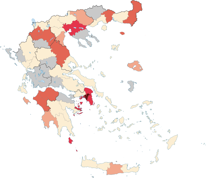
English: Map of the COVID-19 outbreak in Greece as of 29 March 2020 per regional unit (prefecture).
Source: EODY daily report 29-03-2020 Confirmed 1—4
Confirmed 5—9
Confirmed 10—49
Confirmed 50—99
Confirmed 100—199
Confirmed ≥200 |
| ⧼wm-license-information-date⧽ | 2020 |
| ⧼wm-license-information-source⧽ | ⧼Wm-license-own-work⧽ based on File:Prefecture map of Attica (Greece).svg |
| ⧼wm-license-information-author⧽ | Geraki |
.svg&action=edit&redlink=1)
ترخيص
|
تاريخ الملف
اضغط على زمن/تاريخ لرؤية الملف كما بدا في هذا الزمن.
| زمن/تاريخ | صورة مصغرة | الأبعاد | مستخدم | تعليق | |
|---|---|---|---|---|---|
| حالي | ★ مراجعة معتمدة 21:14، 24 أكتوبر 2023 | | 8٬460 × 7٬315 (1٫83 ميجابايت) | Pastakhov (نقاش | مساهمات) | Upload https://upload.wikimedia.org/wikipedia/commons/7/79/COVID-19_Outbreak_Cases_in_Greece_per_regional_unit_%28prefecture%29.svg |
لا يمكنك استبدال هذا الملف.
وصلات
لا يوجد صفحات تصل لهذه الصورة.
.svg&oldid=3236282)