ملف:BattleOfFortWashingtonMapBySauthier.jpg
حجم هذه المعاينة: 330 × 600 بكسل. البعد الآخر: 2٬528 × 4٬595 بكسل.
الملف الأصلي (2٬528 × 4٬595 بكسل حجم الملف: 4٫79 ميجابايت، نوع MIME: image/jpeg)
وصف قصير
| ⧼wm-license-information-description⧽ |
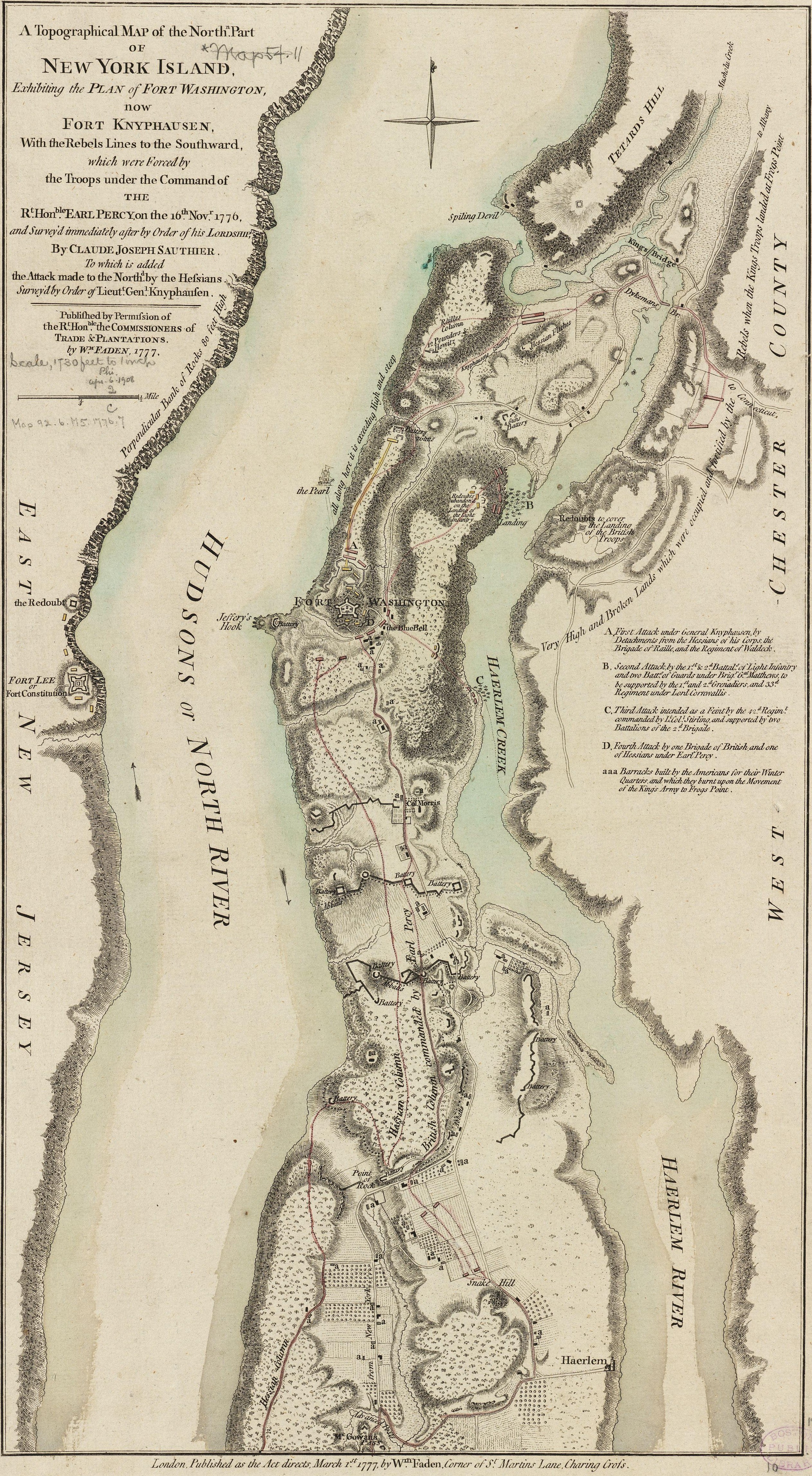
English: This map depicts the northern end of Manhattan, and the military fortifications in the area in 1776, during the American Revolutionary War. It has markings describing the military movements of the Battle of Fort Washington, fought November 16, 1776.
The map's caption reads: A Topographical Map of the Northn. Part of New York Island, Exhibiting the Plan of Fort Washington, now Fort Knyphausen, With the Rebels Lines to the Southward, which were forced by the Troops under the Command of the Rt. Honble. Earl Percy, on the 16th Novr. 1776, and Survey'd immediately after by Order of his Lordship, By Claude Joseph Sauthier. To which is added the Attack made to the Northd. by the Hessians Survey'd by Order of Lieutt. Genl. Knyphausen. Published by Permission of The Rt. Honble. the Commissioners of Trade & Plantations. By Wm. Faden, 1777.
|
| ⧼wm-license-information-date⧽ | 1777 |
| ⧼wm-license-information-source⧽ | From the Boston Public Library Digital Map Collection: http://maps.bpl.org/details_10863/ Call number: G3804.N4S3 1777 .S2 |
| ⧼wm-license-information-author⧽ | صانع:Claude Joseph Sauthier Engraving: صانع:William Faden |
| ⧼wm-license-information-other-versions⧽ |
قالب:Works created more than 200 years ago
ترخيص
The official position taken by the Wikimedia Foundation is that "faithful reproductions of two-dimensional public domain works of art are public domain, and that claims to the contrary represent an assault on the very concept of a public domain". For details, see Commons:When to use the PD-Art tag.
|
تاريخ الملف
اضغط على زمن/تاريخ لرؤية الملف كما بدا في هذا الزمن.
| زمن/تاريخ | صورة مصغرة | الأبعاد | مستخدم | تعليق | |
|---|---|---|---|---|---|
| حالي | ★ مراجعة معتمدة 17:34، 28 نوفمبر 2023 | | 2٬528 × 4٬595 (4٫79 ميجابايت) | Pastakhov (نقاش | مساهمات) | Upload https://upload.wikimedia.org/wikipedia/commons/6/64/BattleOfFortWashingtonMapBySauthier.jpg |
لا يمكنك استبدال هذا الملف.
وصلات
لا يوجد صفحات تصل لهذه الصورة.