ملف:Allies Propaganda map - Central Powers dividing USA - Get ready 1916.jpg
الملف الأصلي (1٬170 × 1٬438 بكسل حجم الملف: 199 كيلوبايت، نوع MIME: image/jpeg)
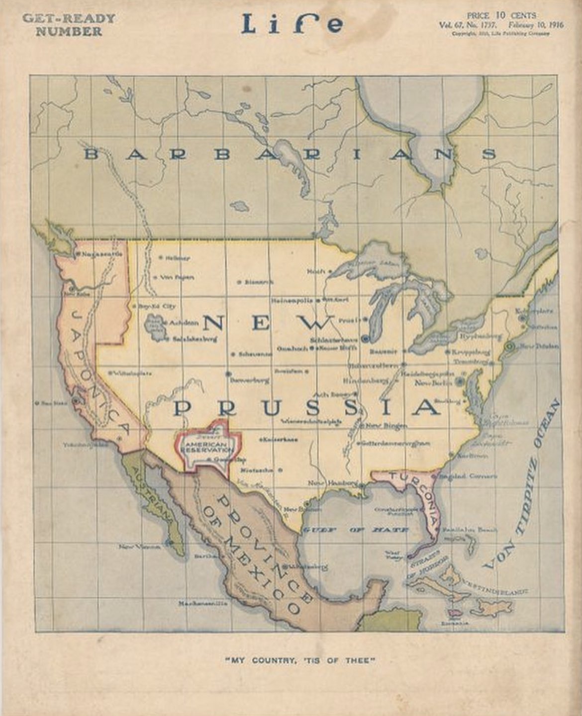
The Allies of World War I crafted this propaganda map in 1916. The intention behind this map was to visualize a hypothetical outcome wherein the Central Powers, predominantly the German Empire and Austria-Hungary, emerged victorious in the conflict.
During World War I, the Central Powers were primarily represented by the German Empire and Austria-Hungary, with their military commonly known as the Prussian Army. The soldiers themselves were often referred to as "Prussians," a term derived from the Kingdom of Prussia.
Delving into the map's intriguing details, one can spot several captivating elements. The Great Lakes, for instance, have been humorously renamed after German beers, injecting a touch of satire. Additionally, numerous American cities have undergone alterations in nomenclature. Boston transforms into "Kulturplatz," while Austin becomes "Nietzsche." Another notable feature is the presence of an American Reservation, with its capital humorously named "Goose-Step," positioned above the Province of Mexico.
Amusingly, the map's creator chose to leave Bismarck, North Dakota unaltered, perhaps as a playful inclusion. However, what stands out most prominently is the labeling of California and the Pacific Northwest as "Japonica," which seems perplexing considering Japan's actual alignment with the Allies, composed of France, Britain, Russia, and Italy, during World War I.[1]
- ^ @historyinmemes (2023-06-1). "The Allies of World War I crafted this propaganda map in 1916". تويتر.
{{cite web}}: Check date values in:|date=(help)
تاريخ الملف
اضغط على زمن/تاريخ لرؤية الملف كما بدا في هذا الزمن.
| زمن/تاريخ | صورة مصغرة | الأبعاد | مستخدم | تعليق | |
|---|---|---|---|---|---|
| حالي | ★ مراجعة معتمدة 14:09، 2 يونيو 2023 | | 1٬170 × 1٬438 (199 كيلوبايت) | Shafei (نقاش | مساهمات) |
لا يمكنك استبدال هذا الملف.
وصلات
الصفحات التالية تحتوي على وصلة لهذه الصورة: