التبت الجنوبية

_(%2Ball_claims_hatched).svg&filetimestamp=20240312001808&)
التبت الجنوبية South Tibet هي ترجمة حرفية للمصطلح الصيني '藏南' (پنين: Zàng Nán)، التي قد تشير إلى أماكن جغرافية مختلفة:
- الجزء الجنوبي من التبت، الذي يغطي القطاع الأوسط من وادي نهر يارلونگ تسانگپو بين ناحية ساگا إلى الغرب و ناحية ماينلينگ إلى الشرق، وكذلك المناطق المجاورة الواقعة بين الهيمالايا إلى الجنوب وسلسلة جبال عبر الهيمالايا إلى الشمال. تمتد المنطقة لنحو 1000 كيلومتر من الغرب إلى الشرق و 300 كيلومتر من الشمال إلى الجنوب. وبهذا التعريف، فإن التبت الجنوبية تضم معظم ما هو اليوم شيگاتسى و لهاسا و محافظة لهوكا (شاننان) و محافظة نيينگتشي.
- التبت الجنوبية قد تشير أيضاً إلى قسم أقصر في الـ يارلونگ تسانگپو وروافده التي تغطي معظم محافظات لهوكا و نيينگتشي من نقطة التقائهما مع نهر لهاسا إلى الغرب وصعوداً إلى بداية يارلونگ تسانگپو، الخندق العظيم بالقرب من ناحية ماينلينگ إلى الشرق.
- حين تُستخدم في سياق النزاع الحدودي الصيني الهندي، فإن التبت الجنوبية هي مصطلح تستخدمه أساساً جمهورية الصين الشعبية للإشارة إلى منطقة جنوب خط مكماهون تقع حالياً تحت إدارة الهند كأجزاء من ولايات أروناتشل پرادش. هذه المنطقة كانت التبت تعترِف بتبعيتها للهند البريطانية خاضعة لاتفاقية خط مكماهون (جزء من اتفاقية سملا (1914)). جمهورية الصين الشعبية لا تعترف بخط مكماهون وتعتبر المنطقة جزءاً من منطقة التبت الذاتية بدلاً من ذلك.[1] وحسب شياو-تينگ لين، الدارس من تايوان، ودارسين آخرين، فإن كلاً من الإدعاءين البريطاني والصيني بالسيادة على المنطقة يمكن اعتبارهما "خياليين إلى حد بعيد"، ولكن يظهران في الخرائط الرسمية والدعاية السياسية.[2][3][4]
الوضع الحالي
Since the beginning of the 21st century, the Sino-Indian boundary situation has tended to ease, and the Sino-Indian boundary issue negotiations have entered a normal track. As of April 2007, China and India have conducted 10 rounds of special representative negotiations on the boundary issue. So far, the South Tibet issue remains unresolved. On the maps of China printed by China, the southern Tibet region actually controlled by India is classified as its own territory. However, most maps printed by foreign countries use the McMahon Line as the eastern section of the border between China and India.
في 4 يونيو 2008، صرح الدالاي لاما الرابع عشر أن ضلع طاونگ في أروناتشل پرادش، الذي هو أيضاً "التبت الجنوبية" التي تطالب بها الصين، هو جزء من الهند. واعترف بمعاهدة عام 1914 بين ممثلين تبتيين وهنود. كما اعترف بصلاحية خط مكماهون الذي حددته معاهدة سملا. أفعال الدالاي لاما الرابع عشر اعتبرتها الصين خيانة وقاطعته الحكومة الصينية.
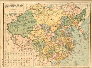
خريطة 1926 لـجمهورية الصين مازالت تضم التبت الجنوبية.
أروناتشل پرادش، الهند
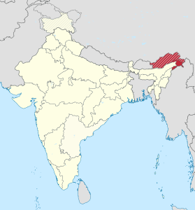
موقع أروناتشل پرادش في الهند


.svg&filetimestamp=20240312001801&)
_(%2Ball_claims_hatched).svg&filetimestamp=20240312001808)
المراجع
- ^ 帝国遗梦:中国印度的三段边境争议 (The Last Dream of an Empire: Three Border Disputes between China and India), BBC News Zhongwen, 27 May 2020.
- ^ Lin, Hsiao-ting (2004), "Boundary, sovereignty, and imagination: Reconsidering the frontier disputes between British India and Republican China, 1914–47", The Journal of Imperial and Commonwealth History 32 (3): 25–47, doi:: "... the professed sovereignties claimed by both Republican China and British India over the Assam-Tibetan tribal territory were largely imaginary, existing merely on official maps and political propagandas. .... More significantly, the war against Japanese encroachment also made it inevitable that the Kuomintang government would be obliged to [..] face the reality that its claimed sovereignty over the Sino-Indian frontier regions was in fact imaginary. ... China's sovereignty over the Tibet-Assam frontier thus existed only in cartography and imagination."
- ^ Guyot-Réchard, Bérénice (2016), Shadow States: India, China and the Himalayas, 1910–1962, Cambridge University Press, pp. 55–57, ISBN 978-1-107-17679-9, https://books.google.com/books?id=FbktDQAAQBAJ&pg=PA186: "The contrast between Republican China's sensitivity towards its imaginary sovereignty and the British Empire's apparent forgetfulness in this regard are connected with the fact that British and Qing expansion attempts had very different 'sovereignty goals' in the eastern Himalayas. [British India's] vision followed an imperial logic: the eastern Himalayas should be a buffer between India and its neighbourhood. Confronted by Chinese expansionism, their aim was limited to achieving external sovereignty over the region – that is, to ensure that no foreign power would intrude into the eastern Himalayas, and that local people would have 'no relations or intercourse with any Foreign Power other than the British Government'."
- ^ Caroe, Olaf (April 1963), "The Sino-Indian Frontier Dispute", Asian Review LIX (218): 72–73, https://archive.org/details/dli.pahar.3235: "[The Times] actually shows the frontier before 1914 down here [at the foothills]; it never was. The Tibetans never penetrated this area, except for one or two monasteries right up in the north of it (طاونگ كان واحداً منهم)، where monks levied certain monastic dues. The fact of the matter is that this area was a tribal, sort of semi-autonomous, area on the frontier of Assam..."
|
|
هذا المقال يضم قائمة من البنود المتعلقة تتشارك في نفس الاسم (أو أسماء متشابهة). لو رابط داخلي، من قبيل الخطأ، أتى بك هنا، فلعلك بحاجة لتعديل الرابط ليشير مباشرةً إلى المقال المقصود. |