صحراء سونورا
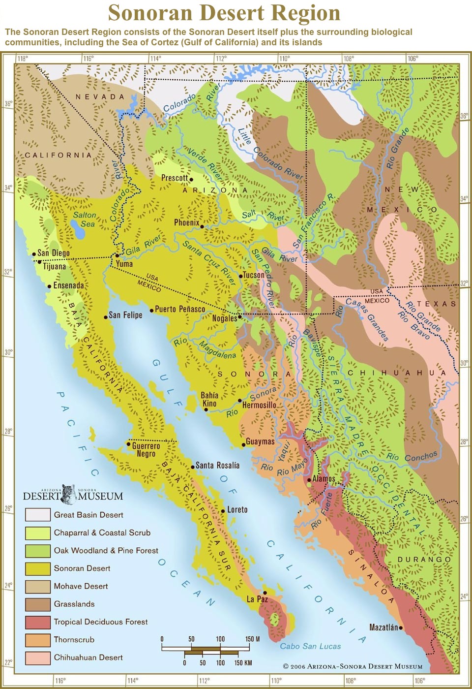
صحراء سونورا (إنگليزية: Sonoran Desert؛ إسپانية: Desierto de Sonora) is a desert in North America and ecoregion that covers the northwestern Mexican states of Sonora, Baja California, and Baja California Sur, as well as part of the southwestern United States (in Arizona and California). It is the hottest desert in both Mexico and the United States.[3] It has an area of 260,000 square kilometers (100,000 sq mi).
| صحراء سونورا Sonoran Desert | |
|---|---|
 | |
 Mojave and Sonoran deserts | |
| علم البيئة | |
| النطاق | Nearctic |
| حيوم | Deserts and xeric shrublands |
| الحدود | قائمة
|
| أنواع الطيور | 246[1] |
| أنواع الثدييات | 120[1] |
| الجغرافيا | |
| المساحة | 222,998 km2 (86,100 sq mi) |
| البلدان | المكسيكو الولايات المتحدة |
| الولايات | أريزونا، كاليفورنيا، باها كاليفورنيا، باها كاليفورنيا سورو سونورا |
| الإحداثيات | 32°15′N 112°55′W / 32.250°N 112.917°WCoordinates: 32°15′N 112°55′W / 32.250°N 112.917°W |
| الأنهار | Colorado River |
| الحفاظ | |
| وضع الحفاظ | Relatively Stable/Intact[2] |
| فقدان الموئل | 10.5%[1] |
| المحمية | 39%[1] |
In phytogeography, the Sonoran Desert is within the Sonoran Floristic province of the Madrean Region of southwestern North America, part of the Holarctic realm of the northern Western Hemisphere. The desert contains a variety of unique endemic plants and animals, notably, the saguaro (Carnegiea gigantea) and organ pipe cactus (Stenocereus thurberi).
The Sonoran Desert is clearly distinct from nearby deserts (e.g., the Great Basin, Mojave, and Chihuahuan deserts) because it provides subtropical warmth in winter and two seasons of rainfall (in contrast, for example, to the Mojave's dry summers and cold winters). This creates an extreme contrast between aridity and moisture.[4]
. . . . . . . . . . . . . . . . . . . . . . . . . . . . . . . . . . . . . . . . . . . . . . . . . . . . . . . . . . . . . . . . . . . . . . . . . . . . . . . . . . . . . . . . . . . . . . . . . . . . . . . . . . . . . . . . . . . . . . . . . . . . . . . . . . . . . . . . . . . . . . . . . . . . . . . . . . . . . . . . . . . . . . . .
الموقع
The Sonoran desert wraps around the northern end of the Gulf of California, from Baja California Sur (El Vizcaíno Biosphere Reserve in central and Pacific west coast, Central Gulf Coast subregion on east to southern tip), north through much of Baja California, excluding the central northwest mountains and Pacific west coast, through southeastern California and southwestern and southern Arizona to western and central parts of Sonora.[5]
It is bounded on the west by the Peninsular Ranges, which separate it from the California chaparral and woodlands (northwest) and Baja California Desert (Vizcaino subregion, central and southeast) ecoregions of the Pacific slope. The Gulf of California xeric scrub ecoregion lies south of the Sonoran desert on the Gulf of California slope of the Baja California Peninsula.
To the north in California and northwest Arizona, the Sonoran Desert transitions to the colder-winter, higher-elevation Mojave, Great Basin, and Colorado Plateau deserts.
The coniferous Arizona Mountains forests are to the northeast. The Chihuahuan Desert and Sierra Madre Occidental pine–oak forests are at higher elevations to the east. To the south the Sonoran–Sinaloan transition subtropical dry forest is the transition zone from the Sonoran Desert to the tropical dry forests of the Mexican state of Sinaloa.[5]
المناطق الفرعية
The desert's sub-regions include the Colorado Desert of southeastern California; and the Yuma Desert east of the north-to-south section of the Colorado River in southwest Arizona. In the 1957 publication Vegetation of the Sonoran Desert, Forrest Shreve divided the Sonoran Desert into seven regions according to characteristic vegetation: Lower Colorado Valley, Arizona Upland, Plains of Sonora, Foothills of Sonora, Central Gulf Coast, Vizcaíno Region, and Magdalena Region.[6] Many ecologists consider Shreve's Vizcaíno and Magdalena regions, which lie on the western side of the Baja California Peninsula, to be a separate ecoregion, the Baja California Desert.
Within the southern Sonoran Desert in Mexico is found the Gran Desierto de Altar, with the El Pinacate y Gran Desierto de Altar Biosphere Reserve, extending 2,000 square kilometers (770 sq mi) of desert and mountainous regions.[7] The biosphere reserve includes the only active erg dune region in North America. The nearest city to the biosphere reserve is Puerto Peñasco ('Rocky Point') in the state of Sonora, Mexico.
- المناطق الفرعية
Sonoran Desert sub-regions include:
المناخ
The Sonoran desert has an arid subtropical climate. In the lower-elevation portions of the desert, temperatures are warm year-round, and rainfall is infrequent and irregular, often less than 90 mm (approx. 3.5”) annually. The Arizona uplands are also warm year-round, but they receive 100–300 mm (approx. 4-12”) of average annual rainfall, which falls in a more regular bi-seasonal pattern.[2]
النبيت

Many plants not only survive, but thrive in the harsh conditions of the Sonoran Desert. Many have evolved to have specialized adaptations to the desert climate. The Sonoran Desert's bi-seasonal rainfall pattern results in more plant species than any other desert in the world.[2] The Sonoran Desert includes plant genera and species from the agave family, palm family, cactus family, legume family, and numerous others.
The Sonoran is the only place in the world where the famous saguaro cactus (Carnegiea gigantea) grows in the wild.[8] Cholla (Cylindropuntia spp.), beavertail (Opuntia basilaris), hedgehog (Echinocereus spp.), fishhook (Ferocactus wislizeni), prickly pear (Opuntia spp.), nightblooming cereus (Peniocereus spp.), and organ pipe (Stenocereus thurberi) are other taxa of cacti found here. Cactus provides food and homes to many desert mammals and birds, with showy flowers in reds, pinks, yellows, and whites, blooming most commonly from late March through June, depending on the species and seasonal temperatures.
Creosote bush (Larrea tridentata) and bur sage (Ambrosia dumosa) dominate valley floors. Indigo bush (Psorothamnus fremontii) and Mormon tea are other shrubs that may be found. Wildflowers of the Sonoran Desert include desert sand verbena (Abronia villosa), desert sunflower (Geraea canescens), and evening primroses.

Ascending from the valley up bajadas, various subtrees such as velvet mesquite (Prosopis velutina), palo verde (Parkinsonia florida), desert ironwood (Olneya tesota), desert willow (Chilopsis linearis ssp. arcuata), and crucifixion thorn (Canotia holacantha) are common, as well as multi-stemmed ocotillo (Fouquieria splendens). Shrubs found at higher elevations include whitethorn acacia (Acacia constricta), fairy duster, and jojoba. In the desert subdivisions found on Baja California, cardon cactus, elephant tree, and boojum tree occur.[9]

The California fan palm (Washingtonia filifera) is found in the Colorado Desert section of the Sonoran Desert, the only native palm in California, among many other introduced Arecaceae genera and species. It is found at spring-fed oases, such as in Anza Borrego Desert State Park, Joshua Tree National Park, and the Kofa National Wildlife Refuge.[10]
الوحيش
The Sonoran Desert is home to a wide variety of animals, birds and other creatures. such as the Gila monster, bobcat, mule deer, antelope jackrabbit, burrowing owl, greater roadrunner, western diamondback rattlesnake, and elf owl. There are three hundred fifty bird species, 20 amphibian species, over 100 reptile species, 30 native fish species, over 1000 native bee species, and more than 2,000 native plant species found in the desert area.[11] The Sonoran Desert area southeast of Tucson and near the Mexican border is vital habitat for the only population of jaguars living within the United States.[12] The Colorado River Delta was once an ecological hotspot within the Sonoran desert due to the Colorado river in this otherwise dry area, but the delta has been greatly reduced in extent due to the damming and use of the river upstream. Species that have higher heat tolerance are able to thrive in the conditions of the Sonoran Desert. One such insect species that has evolved a means to thrive in this environment is Drosophila mettleri, a Sonoran Desert fly. This fly contains a specialized P450 detoxification system that enables it to nest in the cool region of exudate moistened soil. Thus, the fly is one of few that can tolerate the high desert temperatures and successfully reproduce.
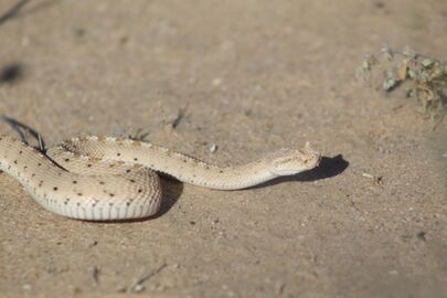
Crotalus cerastes in Puerto Peñasco, Mexico
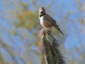
Campylorhynchus brunneicapillus in Phoenix, United States
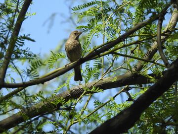
Haemorhous mexicanus in Maricopa County, United States
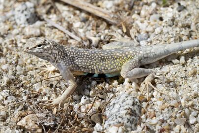
Callisaurus draconoides in Los Cabos, Mexico
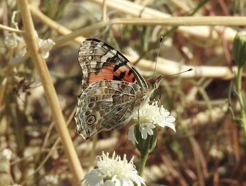
Vanessa cardui in Riverside County, United States
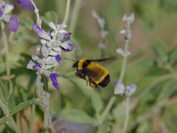
Bombus sonorus in Phoenix, United States


الاستيطان البشري
The Sonoran Desert is home to the cultures of over 17 contemporary Native American tribes, with settlements at American Indian reservations in California and Arizona, as well as populations in Mexico.
The largest city in the Sonoran Desert is Phoenix, Arizona, with a 2017 metropolitan population of about 4.7 million.[13] Located on the Salt River in central Arizona, it is one of the fastest-growing metropolitan areas in the United States. In 2007 in the Phoenix area, desert was losing ground to urban sprawl at a rate of approximately 4,000 square meters (1 acre) per hour.[14]
The next largest cities are Tucson, in southern Arizona, with a metro area population of just over 1 million,[15] and Mexicali, Baja California, with a similarly sized metropolitan population of around 1,000,000. The metropolitan area of Hermosillo, Sonora, has a population close to 900,000. Ciudad Obregón, Sonora, in the southern part of the desert, has a population of 375,800.[16]
كاليفورنيا
The Coachella Valley, located in the Colorado Desert section of the Sonoran Desert, has a population of 365,000. Several famous Southern California desert resort cities such as Palm Springs and Palm Desert are located here.

During the winter months, from November to April, the daytime temperatures in the Coachella Valley range from 70 °F (21 °C) to 90 °F (32 °C) and corresponding nighttime lows range from 46 °F (8 °C) to 68 °F (20 °C) making it a popular winter resort destination. Due to its warm year-round climate citrus and subtropical fruits such as mangoes, figs, and dates are grown in the Coachella Valley and adjacent Imperial Valley. The Imperial Valley has a total population of over 180,000 and has a similar climate to that of the Coachella Valley. Other cities include Borrego Springs, Indio, Coachella, Calexico, El Centro, Imperial, and Blythe.
منطقة الحدود الأمريكية-المكسيكية
Straddling the Mexico–United States border with low levels of human-installed security, the Sonoran desert is a route for unauthorized entry across the border. The harsh conditions mean that the 3-to-5-day march, usually moving at night to minimize exposure to the heat, sometimes results in death.[17]
. . . . . . . . . . . . . . . . . . . . . . . . . . . . . . . . . . . . . . . . . . . . . . . . . . . . . . . . . . . . . . . . . . . . . . . . . . . . . . . . . . . . . . . . . . . . . . . . . . . . . . . . . . . . . . . . . . . . . . . . . . . . . . . . . . . . . . . . . . . . . . . . . . . . . . . . . . . . . . . . . . . . . . . .
المناطق المحمية

There are many National Parks and Monuments; federal and state nature reserves and wildlife refuges; state, county, and city parks; and government or nonprofit group operated natural history museums, science research institutes, and botanical gardens and desert landscape gardens.
- المناطق المحمية بصحراء سونورا تضم
- Arizona–Sonora Desert Museum
- Sonoran Desert National Monument [18]
- Boyce Thompson Arboretum State Park – Sonoran Desert flora arboretum
- Anza–Borrego Desert State Park
- Organ Pipe Cactus National Monument
- Saguaro National Park
- Joshua Tree National Park
- Reserva de la Biosfera el Pinacate y Gran Desierto de Altar – Pinacate National Park, in Sonora, Mexico
- Indio Hills Palms State Reserve
- Coachella Valley National Wildlife Refuge
- Cabeza Prieta National Wildlife Refuge
- Kofa National Wildlife Refuge
- South Mountain Park
- Sonoran Arthropod Studies Institute
- Skyline Regional Park
انظر أيضاً
المراجع
- ^ أ ب ت ث "The Atlas of Global Conservation". maps.tnc.org. Retrieved 2020-11-16.
- ^ أ ب ت قالب:WWF ecoregion
- ^ "The hottest surface temperatures on earth" (in الإنجليزية). American Meteorological Society. 21 May 2021. Retrieved 12 March 2023.
- ^ A Delicate Balance (in الإنجليزية). National Park Service. 15 November 2020. Retrieved 6 December 2020.
- ^ أ ب "Arizona-Sonora Desert Museum, Tucson, AZ – Zoo, Botanical Garden and Art Gallery". www.desertmuseum.org. Retrieved 15 April 2018.
- ^ "Sonoran Desert: An Overview of the Sonoran Desert by William G. McGinnies". 21 January 2003. Archived from the original on 21 January 2003. Retrieved 15 April 2018.
- ^ "Pinacate Rocky Point Puerto Peñasco Sonora Mexico". Archived from the original on 2011-02-02. Retrieved 2010-03-02.
- ^ "The Saguaro Cactus" (PDF). nps.gov. Retrieved 15 April 2018.
- ^ MacMahon, J. A. Deserts. 1986, 638 pages
- ^ Hogan, C. M. 2009. California Fan Palm: Washingtonia filifera, GlobalTwitcher.com, ed. N. Stromberg Archived 2009-09-30 at the Wayback Machine
- ^ Surviving the Sonoran Archived 2010-04-30 at the Wayback Machine
- ^ The Jaguar in the Borderlands of Arizona, New Mexico and Northern Mexico: Conservation – Threats & Strategies Archived 2009-03-30 at the Wayback Machine
- ^ "U.S. Census website". United States Census Bureau. Retrieved 2019-01-31.
- ^ Make No Small Plans, Adelheid Fischer, ASU Research magazine. Accessed on line October 15, 2007
- ^ Table 1: Annual Estimates of the Population of Metropolitan and Micropolitan Statistical Areas: April 1, 2000 to July 1, 2006 (CBSA-EST2006-01) Archived سبتمبر 14, 2007 at the Wayback Machine, United States Census Bureau, 2007-04-05. Accessed 2007-09-11
- ^ "Población en municipios de zonas metropolitanas". SEMARNAT. 2015.
{{cite web}}: CS1 maint: url-status (link) - ^ Arizona: Naming the dead from the desert, BBC News, 17 January 2013
- ^ The Sonoran Desert National Monument was created in 2001 in Arizona, to enhance protection of the unique resources of the Sonoran Desert, with 2,008 square kilometers (496,000 acres).
:Reference: Sonoran Desert National Monument Archived 2009-01-26 at the Wayback Machine, Bureau of Land Management, U. S. Department of the Interior. Accessed on line June 17, 2009.
وصلات خارجية
- Arizona–Sonora Desert Museum
- Timeline of the Sonoran desert
- An Overview of the Sonoran Desert, by William G. McGinnies
- The Sonoran Desert Naturalist
- Very short overview of Sonoran Desert Geology
- Sonoran Desert images at bioimages.vanderbilt.edu (slow modem version)
- International Sonoran Desert Alliance
- Sounds of the Sonoran Desert)
المنتزهات ومناطق الترفيه
- Sonoran Desert National Monument: official website
- Saguaro National Park: official website
- Anza–Borrego Desert State: official website
- Organ Pipe Cactus National Monument: official website
- Joshua Tree National Park: official website
- South Mountain Park – Preserve
- Arizona State Parks: official website (desert plants)