گوقچى (جزيرة)
گوقچى Gökçeada هي جزيرة ومقاطعة في Çanakkale Province بتركيا. Its seat is the town of Gökçeada.[1] Its area is 282 km2,[2] and its population is 10,377 (2021).[3]
Gökçeada | |
|---|---|
تجمع سكاني | |
 Map showing Gökçeada District in Çanakkale Province | |
 Gökçeada Location in Turkey | |
| الإحداثيات: 40°10′N 25°51′E / 40.167°N 25.850°ECoordinates: 40°10′N 25°51′E / 40.167°N 25.850°E | |
| البلد | تركيا |
| المحافظة | Çanakkale |
| المقر | Gökçeada |
| الحكومة | |
| المساحة | 282 كم² (109 ميل²) |
| التعداد (2021) | 10٬377 |
| • الكثافة | 37/km2 (95/sq mi) |
| منطقة التوقيت | TRT (UTC+3) |
| Postal code | 17760 |
| الموقع الإلكتروني | www |
The district consists of the island of Imbros (Turkish: Gökçeada), the largest island in Turkey. The mayor of Gökçeada municipality is Ünal Çetin (İYİ). The district governor (kaymakam) is Serhat Doğan.
. . . . . . . . . . . . . . . . . . . . . . . . . . . . . . . . . . . . . . . . . . . . . . . . . . . . . . . . . . . . . . . . . . . . . . . . . . . . . . . . . . . . . . . . . . . . . . . . . . . . . . . . . . . . . . . . . . . . . . . . . . . . . . . . . . . . . . . . . . . . . . . . . . . . . . . . . . . . . . . . . . . . . . . .
Composition
There is one municipality in Gökçeada District:[1]
There are 9 villages in Gökçeada District:[4]
- Bademli, both Greek and Turkish (Greek majority with one small difference, very close Turkish population)
- Dereköy, Turkish majority, Greek minority
- Eşelek, Turkish majority (full)
- Kaleköy, Turkish majority (full)
- Şirinköy, Turkish majority (full)
- Tepeköy, Greek majority, Turkish minority
- Uğurlu, Turkish majority (full)
- Yenibademli, Turkish majority (full)
- Zeytinliköy, Greek majority, Turkish minority
معرض صور
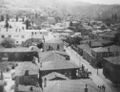
Gökçeada 1967
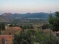
Zeytinli
Zeytinli
Three Royal Navy midshipmen, George Drewry, Wilfred Malleson and Greg Russell, having a picnic on Imbros during the Battle of Gallipoli
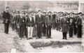
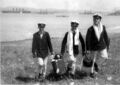
Students of "İmroz İlköğretmen Okulu/Imbros Education High School" in military training class, 03.12.1967


المراجع
- ^ أ ب İlçe Belediyesi, Turkey Civil Administration Departments Inventory. Retrieved 1 March 2023.
- ^ "İl ve İlçe Yüz ölçümleri". General Directorate of Mapping. Retrieved 1 March 2023.
- ^ "Address-based population registration system (ADNKS) results dated 31 December 2021" (XLS) (in التركية). TÜİK. Retrieved 1 March 2023.
- ^ Köy, Turkey Civil Administration Departments Inventory. Retrieved 1 March 2023.