محافظة أرارات
أرارات (بالأرمينية: Արարատ، النُطق الأرمني: [ɑɾɑˈɾɑt] (![]() استمع))، هي محافظة في أرمينيا. عاصمتها هي آرتاشات وهي أكبر مدنها.
استمع))، هي محافظة في أرمينيا. عاصمتها هي آرتاشات وهي أكبر مدنها.
Ararat
Արարատ | |
|---|---|
.svg&filetimestamp=20220706124534&) Location of Ararat within Armenia | |
| الإحداثيات: 39°55′N 44°43′E / 39.917°N 44.717°ECoordinates: 39°55′N 44°43′E / 39.917°N 44.717°E | |
| دولة | |
| العاصمة and largest city | آرتاشات |
| الحكومة | |
| • محافظ | سدراك تڤونيان[2] |
| المساحة | |
| • الإجمالي | 2٬090 كم² (810 ميل²) |
| ترتيب المساحة | التاسعة |
| التعداد (2011) | |
| • الإجمالي | 260٬367[1] |
| • Estimate (1 January 2019) | 256٬700[3] |
| • الترتيب | الثالثة |
| منطقة التوقيت | AMT (UTC+04) |
| الرمز البريدي | 0601-0823 |
| ISO 3166 code | AM.AR |
| FIPS 10-4 | AM02 |
| HDI (2017) | 0.728[4] high · 8th |
| الموقع الإلكتروني | Official website |
سميت المحافظة على جبل أرارات المذكور في الكتاب المقدس. يحدها تركيا من الغرب وأذربيجان جمهورية نخجوان الذاتية من الجنوب. وهي تحيط بـكركي المعزولة التي كانت تسيطر عليها أرمينيا منذ الاستيلاء عليها في مايو 1992 أثناء حرب ناگورنو قرةباخ الأولى. محليًا، تحد أرارات محافظة أرماڤير من الشمال الغربي، ومحافظة كوتايك من الشمال، ومحافظة گغاركونيك من الشرق، ومحافظة ڤايوتس دزور من الجنوب الشرقي ومدينة يريڤان من الشمال.
توجد عاصمتان سابقتان لأرمينيا في مقاطعة أرارات الحديثة، أرتاكساتا ودوين. كما أنها موطن لدير خور ڤيراپ ، وهو مكان ذو أهمية كمكان سجن گريگوري المنور لمدة 13 عامًا وأقرب نقطة إلى جبل أرارات داخل الحدود الأرمنية.
. . . . . . . . . . . . . . . . . . . . . . . . . . . . . . . . . . . . . . . . . . . . . . . . . . . . . . . . . . . . . . . . . . . . . . . . . . . . . . . . . . . . . . . . . . . . . . . . . . . . . . . . . . . . . . . . . . . . . . . . . . . . . . . . . . . . . . . . . . . . . . . . . . . . . . . . . . . . . . . . . . . . . . . .
التسمية
تمت تسمية مقاطعة أرارات على اسم مقاطعة أيرارات التاريخية في أرمينيا القديمة.
وفقًا لـموڤسيس خوريناتسي وكتاب أشخارهاتس الجغرافي لأنانيا شيراكاتسي الذي كتبه في زمن أرمينيا القروسطية، كانت أيرارات واحدة من 15 مقاطعة في أرمينيا الكبرى. كانت تعتبر المقاطعة المركزية في المرتفعات الأرمنية.
يُعتقد أن اسم "أرارات" هو الاسم الأرميني المقابل لاسم موقع أورارتو.[5][6]
الجغرافيا
.jpg&filetimestamp=20220706124522&)
تبلغ مساحة أرارات 2090 كلم (أي 7% من إجمالي مساحة أرمينيا). تحتل شرق الجزء الأوسط من أرمينيا الحديثة. من الشمال لها حدود مع محافظة أرماڤير ويريڤان ومحافظة كوتايك. من الشرق، يحدها جيغاركونيك ومحافظة ڤايوتس دزور. تشكل محافظة إغدير في تركيا وجمهورية نخجوان الذاتية داخل أذربيجان الحدود الغربية والجنوبية للمقاطعة.
تاريخيًا، تحتل الأراضي الحالية للإقليم بشكل رئيسي كانتون ڤوستان هايوتس في مقاطعة ايرارات في أرمينيا القديمة.

تقع المقاطعة في الجنوب الشرقي من سهل أرارات، وتحيط بها جبال إرانوس من الشمال، وجبال گغام ، ودهنك ومزكتر من الشرق، وجبال أورتس من الجنوب و نهر أراكس من الغرب. تقع جبال يراخ في وسط المحافظة. ما يقرب من 30% من الأراضي سهل، بينما تهيمن الجبال على الباقي.
أعلى نقطة في مقاطعة أرارات هي قمة سپيتاكاسار في جبال گغام التي يبلغ ارتفاعها 3560 مترًا. أخفض نقطة 801 متر في وادي أراكس. أراكس، وهرازدان، وعزت وڤيدي، هي الأنهار الأربعة الرئيسية التي تتدفق عبر المحافظة. المناخ داخل أراضي المقاطعة متنوع للغاية. ويتراوح المناخ بين المناخ الجاف للغاية في السهول المنخفضة والمناخ الثلجي البارد في المرتفعات.
كانت التضاريس المنحدرة لغابة خسروف الواقعة في الشمال الشرقي من المقاطعة، معقلًا للكائنات مهددة بالانقراض مثل النمر القوقازي في أرمينيا. بين أكتوبر 2000 ويوليو 2002 تم العثور على آثار لا تزيد عن 10 أفراد في منطقة تبلغ مساحتها 780 km2 (300 sq mi).[7]
التاريخ

منطقة مقاطعة أرارات الحديثة هي من بين أقدم المواقع التي استوطنها سكان المرتفعات الأرمنية. وهي تشمل بشكل أساسي كانتونات ڤوستان هايوتس وأورستادزور وآراتس في المقاطعة التاريخية أيرارات. عُرفت ڤوستان هايوتس منذ تأسيس مملكة أرتاشاتاد في أرمينيا في بداية القرن الثاني قبل الميلاد. تأسست العواصم الأرمنية القديمة آرتاشاتا في 176 قبل الميلاد، و دڤين التي تأسست خلال القرن الرابع الميلادي ، كانتا تقعان داخل كانتون ڤوستان هايوتس. تم ذكر كانتوناس أورتسادزور وأراتسالأخرى لأول مرة في القرن الخامس الميلادي بواسطة المؤرخ يغيشي في كتابه التاريخي "تاريخ ڤاردان والحرب الأرمنيية"
بعد سقول المملكة الأرمينية عام 428، أصبحت المنطقة جزءا من الامبراطورية الساسانية في فارس حتى الفتح العربي لأرمنيا في منتصف القرن السابع، وفقًا لمؤرخ القرن الثامن غڤنود، شارك الأمراء الأرمن في كانتون "أورتسادزور" في ثورة 775 الفاشلة في إرجيش ضد العباسيين حكام أرمينيا.

في نهاية القرن التاسع ، أصبحت الكانتونات الثلاثة جزءًا من أرمنيا البقردونية. ومع ذلك، بين القرنين الحادي عشر والخامس عشر، عانت المنطقة من غزوات أغ كويونلو وكارا كويونلو السلجوقية والمغولية على التوالي. في بداية القرن السادس عشر ، أصبحت أراضي أرارات الحديثة جزءًا من "إريڤان البكلربكية" ضمن السلالة الصفوية بلاد فارس الصفوية. خلال النصف الأول من القرن الثامن عشر، أصبحت المنطقة جزءًا من خانات إريڤان تحت حكم الأسرة الأفشارية ولاحقًا في ظل سلالة القاجار من بلاد فارس. ظلت تحت الحكم الفارسي حتى 1827-1828، عندما تنازلت الإمبراطورية الروسية عن أرمينيا الشرقية نتيجة لحرب الروسية الفارسية 1826-1828 وتوقيع معاهدة تركمنچاي. مع سقوط الإمبراطورية الروسية ونتيجة الانتصارات الأرمنية الحاسمة على الأتراك في معارك سردار آباد ومعركة أباران أباران وكاراكيليسا، أصبحت المنطقة جزءًا من أرمينيا المستقلة في مايو 1918.
بعد عامين من الاستقلال القصير، أصبحت أرمينيا جزءًا من الاتحاد السوڤيتي في ديسمبر 1920. من عام 1930 حتى عام 1995، تم تقسيم أرارات الحديثة إلى 3 رايون داخل جمهورية أرمينيا الاشتراكية السوڤيتية: رايون ماسيس ورايون آرتاشاتا ورايون أرارات (المعروفة باسم رايون ڤدي حتى عام 1968). مع إصلاح الإدارة الإقليمية لعام 1995 ، تم دمج 3 رايونات لتشكيل مقاطعة أرارات.
Demographics
Population
According to the 1989 Soviet census, the Ararat Province (then part of the Ararat, Artashat, and Masis districts in 1930–1995)[8] had a population of 266,527. 52,429 or 19.67% of which was urban, distributed in the cities of Ararat (20,105) and Artashat (32,324), and 214,098 or 80.33% were rural, distributed in the districts of Ararat (64,657), Artashat (73,269), and Masis (76,172).[9]

According to the 2011 official census, Ararat has a population of 260,367 (74,103 men and 133,146 women), forming around 8.6% of the entire population of Armenia. The urban population is 74,103 (28.46%) and the rural is 186,264 (71.54%). The province has 4 urban and 93 rural communities. The largest urban community is the provincial centre of Artashat, with a population of 22,269. The other urban centres are Ararat, Masis and Vedi.
With a population of 8,376, the village of Ayntap is the largest rural municipality of Ararat.
Ethnic groups and religion
The majority of the Ararat Province population are ethnic Armenians who belong to the Armenian Apostolic Church. The regulating body of the church is the Araratian Pontifical Diocese, headed by Archbishop Navasard Kchoyan (seat in Yerevan).
However, the village of Verin Dvin is predominantly populated by Assyrians belonging to the Assyrian Church of the East, whose ancestors migrated to Armenia from Iran during the 1st half of the 19th century. Almost half of the population of the village of Dimitrov is also Assyrian. The provincial centre Artashat is also home to a small Assyrian community. The approximate number of the Assyrians in Ararat Province is around 2,500.
Administrative divisions

Ararat is currently divided into 95 municipal communities (hamaynkner), of which 4 are urban and 91 are rural:[10]
| Municipality | Type | Area (km2) | Population (2017 est.) |
Centre | Included villages |
|---|---|---|---|---|---|
| Ararat Municipality | Urban | 6 | 20,300 | Ararat | |
| Artashat Municipality | Urban | 12 | 20,700 | Artashat | |
| Masis Municipality | Urban | 6 | 20,500 | Masis | |
| Vedi Municipality | Urban | 5.5 | 11,600 | Vedi |
Rural communities and included settlements:
- Abovyan
- Araksavan
- Aralez
- Ararat
- Arbat
- Arevabuyr
- Argavand
- Arevshat
- Armash
- Avshar
- Aygepat
- Aygestan
- Aygavan
- Aygezard
- Ayntap
- Azatashen
- Azatavan
- Baghramyan
- Bardzrashen
- Berdik
- Berkanush
- Burastan
- Byuravan
- Dalar
- Darakert
- Darbnik
- Dashtakar
- Dashtavan
- Deghdzut
- Dimitrov
- Ditak
- Dvin
- Geghanist
- Getapnya
- Getazat
- Ghukasavan
- Ginevet
- Goravan
- Hayanist
- Hnaberd
- Hovtashat
- Hovtashen
- Jrahovit
- Jrashen
- Kaghtsrashen
- Kanachut
- Khachpar
- Lanjar
- Lanjazat
- Lusarat
- Lusashogh
- Marmarashen
- Masis
- Mkhchyan
- Mrganush
- Mrgavan
- Mrgavet
- Narek
- Nizami
- Nor Kharberd
- Nor Kyank
- Nor Kyurin
- Nor Ughi
- Norabats
- Noramarg
- Norashen
- Noyakert
- Nshavan
- Paruyr Sevak
- Pokr Vedi
- Ranchpar
- Sayat-Nova
- Shahumyan
- Sipanik
- Sis
- Sisavan
- Surenavan
- Taperakan
- Urtsadzor
- Urtsalanj
- Vanashen
- Vardashat
- Vardashen
- Verin Artashat
- Verin Dvin
- Vosketap
- Vostan
- Yeghegnavan
- Yeraskh
- Zangakatun
- Zorak
During the recent years, many rural settlements in Ararat became abandoned, including the village of Kakavaberd.
. . . . . . . . . . . . . . . . . . . . . . . . . . . . . . . . . . . . . . . . . . . . . . . . . . . . . . . . . . . . . . . . . . . . . . . . . . . . . . . . . . . . . . . . . . . . . . . . . . . . . . . . . . . . . . . . . . . . . . . . . . . . . . . . . . . . . . . . . . . . . . . . . . . . . . . . . . . . . . . . . . . . . . . .
Culture


There are cultural palaces as well as public libraries in the towns of Ararat, Artashat, Masis and Vedi. The provincial centre Artashat is also home to the Amo Kharazyan drama theatre.
The province has many art academies, sport schools and musical schools, mainly in the urban settlements.
The House-museum of Vazgen Sargsyan is operating in the village of Ararat since 2001.
Fortresses and archaeological sites
- Ancient Artashat archaeological site,
- Ancient Dvin archaeological site,
- Kakavaberd fortress of the 4th century,
- Tapi Fortress of the 10th century,
- Mausoleum of Kara Koyunlu emirs in Argavand, built in 1413.
Churches and monasteries
- Aghjots Vank monastery of the 13th century,
- Hovhannes Karapaet Monastery near Shaghap, from the 13th century,
- Khor Virap monastery of the 17th century.
Transportation
The M-2 Motorway that connects the capital Yerevan with southern Armenia and the Iranian border, passes through the Ararat Province.
The towns of Artashat and Ararat used to have a railway station that connected Yerevan with the Nakhchivan Autonomous Republic during the Soviet years.
Economy
Agriculture and viticulture

.jpg&filetimestamp=20220706124633&)
Being located at the fertile Ararat plain, the province contributes with 15% in the annual total agricultural product of Armenia.[11] Around 75% (1,567 km2) of the total area of the province are arable lands, out of which 17.23% (270 km2) are ploughed.[12]
Orchards mainly produce grapes, apricot and peach. Other products include pear, apple, melon, watermelon, eggplant, grains and dry seed. Ararat is among the leading provinces of Armenia in wine production in terms of grape cultivation and wine export (along with the provinces of Ararat and Vayots Dzor).
The irrigation infrastructure of the province is quite developed. 90% of the farmlands are irrigated, mainly using canals opened from the rivers of Vedi and Azat.
The Geghanist village has a specialized plant in producing fertilizers and irrigation system design.
The province has 2 large poultry farms in the village of Kaghtsrashen and the town of Masis.
Recently, fish farming has significantly developed in the province. The largest fish farming ponds are located at the vicinity of Armash village.
Industry
Ararat is among the most industrialized provinces of Armenia with many large industrial firms. It currently has a contribution of 10% in the annual total industrial product of Armenia.

- Production of alcoholic drinks is among the leading sectors in Ararat with a large number of factories spread all over the communities of the province. Major producers of the province include:
- Aregak Brandy Factory, founded in 1889 in Dalar (privatized in 1992).
- Ararat Wine Factory, founded in 1903 in Ararat village.
- Artashat Vincon Winery, founded in 1905 in Mkhchyan (privatized in 1995).
- Ararat Cognac Factory AKZ for brandy and wine, opened in 1932 in Avshar.
- Aygezard Wine Factory, founded in 1936 in Aygepat.
- Vedi Alco Winery for wine, brandy and vodka, founded in 1956 in Ginevet (privatized in 1994).
- Avshar Wine Factory for wine, brandy and vodka, founded in 1968 in Avshar (privatized in 1995).
- Yeraskh Wine Factory, founded in 1970 in Yeraskh.
- Van 777 Winery for wine and brandy, founded in 1992 in Taperakan.
- Agatat-Gold Winery for wine, brandy and vodka, founded in 2007 in Nor Kyurin.
- Shato Arno Winery for wine and brandy, founded in 2002 in Ayntap.
- Tavinko Winery for wine and brandy, founded in 2006 in Taperakan.
- Mrganush Brandy Factory for vodka and brandy, opened in 2002 in Mrganush
- Shaumyan-Vin Winery (wine, brandy, vodka), opened in 2006 in Shahumyan.
- Shaumyan Alco for brandy and vodka, opened in 2007 in Artashat.
- Abrikon Distillery for apricot vodka, opened in 2010 in Ararat village.
- "Proshyan Brandy Factory-Aygestan Branch", in Aygestan.
- Preserved food production is also developed in the province. The "Artfood" Artashat Cannery (since 1961), the "Araratyan LLC" for dairy products in Kaghtsrashen, the "Lula LLC" for dairy products in Dalar, and the "Armenian Dried Fruits" plant of Surenavan (since 2007) are the leading firms in this sector.
- The town of Masis has an industrial hub that is home to many large firms. The town is a major centre for tobacco products in Armenia with its two factories: the "Masis Tobacco" company (SINCE 1999) and the "International Masis Tabak" company (since 2002). Other industries of Masis include the "ElektraMachTrade" factory for industrial equipments (since 1979), the "Grand-Master" corrugated cardboard packaging manufacturing ang label printing factory (since 1995), the "Masis Garun" clothing factory (since 1995), the "Berma" plant for asphalt concrete (since 1997), and the "Medical Horizon" factory for drugs and pharmaceuticals (since 2005).

- The town of Ararat is home to the "Ararat Cement" factory and the "Geopromining Gold" recovery plant. However, there is a major controversy over the pollution and the toxic waste caused by the various enterprises based on the manufacturing of building materials and the gold processing facility in the town of Ararat. The Ararat Gold Recovery extracts gold from the raw ore sent from the gold mine in Sotk located 20 kilometres (12 miles) east of Lake Sevan.[13] About 0.46 grams of gold is extracted from each ton of sand unearthed at the mines. The extraction process involves first pulverizing the raw material, and then filtering out the gold using a cyanide nitrate chemical process.[13] The soupy byproduct of the cyanide nitrate chemical process is both toxic and radioactive and collects in a tailing dam. There have been numerous incidents of animals dying near and around the plant's area.[13] Also, within the years 2003 and 2008, there have been at least 10 accidents at the plant, some of which have resulted in the discharge of the cyanide soup into neighboring agricultural lands and fisheries, killing off cows and fish stock.[13]
- Other major firms in the province include the "AraratShin" construction company and building materials producers in Ararat (since 1984), the "Manana Stone" plant for building materials in Surenavan (since 1995), the "Vedi Plast" plastic products plant (since 1998) in Vedi, the "Zovashen" company for electrical power plants in Lanjazat (since 2001), the "Abit" Armenian-Russian asphalt factory (since 2009) in Surenavan, the "Izipanel" sandwich panels manufacturing plant in Artashat (since 2012), the "Ararat Group" mineral water factory in Artashat (since 2012), the "Kavashen" plant for building materials in Ararat, and the "Travertine" stone-processing plant in Vedi.
. . . . . . . . . . . . . . . . . . . . . . . . . . . . . . . . . . . . . . . . . . . . . . . . . . . . . . . . . . . . . . . . . . . . . . . . . . . . . . . . . . . . . . . . . . . . . . . . . . . . . . . . . . . . . . . . . . . . . . . . . . . . . . . . . . . . . . . . . . . . . . . . . . . . . . . . . . . . . . . . . . . . . . . .
Tourism
.JPG&filetimestamp=20220706124614&)
The Khor Virap monastery is among the regular tourist destinations in Ararat Province. The ancient settlements of Artaxata and Dvin are among the attractive sites for archaeologists.
The province is home to many protected areas of nature including the Khosrov Forest State Reserve, the Goravan Sands Sanctuary and the Khor Virap Wildlife Sanctuary.
Education
As of the 2015-16 educational year, Ararat Province has 112 schools,[14] out of which 107 are operated by the province administration, while 5 are under the direct supervision of the Ministry of Education and Science. As of the end of 2015, the number of the students in the schools of the province is 31,457.[15]
There are many public libraries and cultural houses in the towns of Artashat, Ararat, Masis and Vedi.
However, there are no higher education institutions in the province.
Sport

Araks Ararat founded in 1960 had represented the province in domestic and international football competitions. However, the club was and dissolved in 2001 due to financial difficulties.
At the end of 2001, another football club with the name of FC Araks was founded in Ararat, but lasted only 4 years before being dissolved.
FC Dvin Artashat founded in 1982, was also a prominent football club in the province. The remained in professional football until 1999, before being dissolved like most Armenian football clubs outside the capital Yerevan.
Masis FC played in the domestic completions between 1992 and 1994 when they were also dissolved.
There are 2 stadiums in the province: the Ayg Stadium of Ararat and the Artashat City Stadium. The latter is the regular home of the annual National Athletics Championship of Armenia.
Gallery
- Ararat
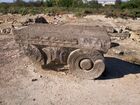
Capital of Saint Gregory Cathedral, ancient Dvin
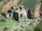
The remains of Aghjots Vank monastery
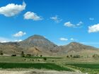
Mount Kotuts of the Urts mountain range at the centre of the province
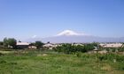
Ararat from Nor Kyurin village


.jpg&filetimestamp=20220706124522)
.jpg&filetimestamp=20220706124633)
.JPG&filetimestamp=20220706124614)
See also
References
- ^ "ՀՀ Արարատի մարզի ցուցանիշները / Հայաստանի Հանրապետության վիճակագրական կոմիտե". armstat.am.
- ^ LLC, Helix Consulting. "Government - Regions - The Government of the Republic of Armenia". www.gov.am.
- ^ "Statistical Committee of the Republic of Armenia".
- ^ "Sub-national HDI - Area Database - Global Data Lab". hdi.globaldatalab.org (in الإنجليزية). Retrieved 2018-09-13.
- ^ http://www.iranicaonline.org/articles/ayrarat Encyclopædia Iranica Online
- ^ "Ararat". Jewish Virtual Library. 2008. Retrieved 27 July 2009.
- ^ Khorozyan, I., Malkhasyan, A. (2002). Ecology of the leopard (Panthera pardus) in Khosrov Reserve, Armenia: implications for conservation. Scientific Reports of the Zoological Society “La Torbiera” 6: 1–41.
- ^ "Legislation: National Assemly of RA". www.parliament.am. Retrieved 2022-02-11.
- ^ "Демоскоп Weekly - Приложение. Справочник статистических показателей". www.demoscope.ru. Retrieved 2022-02-10.
- ^ "RA Ararat Marz" (PDF). Marzes of the Republic of Armenia in Figures, 2002–2006. National Statistical Service of the Republic of Armenia. 2007.
- ^ "Armstat: Ararat" (PDF).
- ^ "R2E2 – Հայաստանի վերականգնվող Էներգետիկայի և էներգախնայողության հիմնադրամ".
- ^ أ ب ت ث Behind Gold's Luster Lie Lands Torn Asunder and Urgent Questions Archived 2012-02-17 at the Wayback Machine, Hetq Online, May 19, 2008.
- ^ "Ararat Province schools" (PDF). Archived from the original (PDF) on 2016-03-05. Retrieved 2015-12-07.
- ^ "Արարատի մարզի 78 դպրոցները տաքացվում են լոկալ ջեռուցման համակարգով". armenpress.am.