سمرست
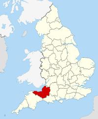
سومرست (إنگليزية: Somerset؛ /ˈsʌmərsɛt/ أو /ˈsʌmərsɪt/) هي مقاطعة في جنوب غرب إنگلترة. عاصمة المقاطعة هي بلدةتاونتون . يحد مقاطعة سمرست مقاطعة بريستول و غلوسترشير إلى الشمال وويلتشير إلى الشرق، ودورست إلى الجنوب الشرقي، وديفون في الجنوب الغربي. ويحدها إلى الشمال الساحل الغربي لقناة بريستول ومصب نهر سيفيرن. سومرست هي مقاطعة ريفية يتخللها العديد من التلال مثل تلال مينديب ومنتزه أكسمور الوطنية يتخلل سومرست العديد من الأودية والمساحات المفتوحة وبها منطقة تسمى طبقات سومرست.
سمرست
Somerset | |||||||||||||||||||||||||||||||||||||||||||||
|---|---|---|---|---|---|---|---|---|---|---|---|---|---|---|---|---|---|---|---|---|---|---|---|---|---|---|---|---|---|---|---|---|---|---|---|---|---|---|---|---|---|---|---|---|---|
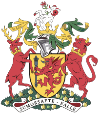
| الشعار: Sumorsǣte ealle ('كل شعب سمرست') | |||||||||||||||||||||||||||||||||||||||||||||
 | |||||||||||||||||||||||||||||||||||||||||||||
| البلد | المملكة المتحدة | ||||||||||||||||||||||||||||||||||||||||||||
| المقاطعة | إنگلترة | ||||||||||||||||||||||||||||||||||||||||||||
| المنطقة | جنوب غرب إنگلترة | ||||||||||||||||||||||||||||||||||||||||||||
| التأسيس | Historic | ||||||||||||||||||||||||||||||||||||||||||||
| منطقة التوقيت | UTC±00:00 (توقيت گرينتش المتوسط) | ||||||||||||||||||||||||||||||||||||||||||||
| • الصيف (التوقيت الصيفي) | UTC+01:00 (توقيت بريطانيا الصيفي) | ||||||||||||||||||||||||||||||||||||||||||||
| أعضاء البرلمان |
| ||||||||||||||||||||||||||||||||||||||||||||
| |||||||||||||||||||||||||||||||||||||||||||||
. . . . . . . . . . . . . . . . . . . . . . . . . . . . . . . . . . . . . . . . . . . . . . . . . . . . . . . . . . . . . . . . . . . . . . . . . . . . . . . . . . . . . . . . . . . . . . . . . . . . . . . . . . . . . . . . . . . . . . . . . . . . . . . . . . . . . . . . . . . . . . . . . . . . . . . . . . . . . . . . . . . . . . . .
الجغرافيا
الخط الساحلي
المناخ
| بيانات مناخ بيانات يوڤلتون، إنگلترة (1971–2000) | |||||||||||||
|---|---|---|---|---|---|---|---|---|---|---|---|---|---|
| الشهر | يناير | فبراير | مارس | أبريل | مايو | يونيو | يوليو | أغسطس | سبتمبر | اكتوبر | نوفمبر | ديسمبر | العام |
| العظمى المتوسطة °س (°ف) | 8.1 (46.6) |
8.3 (46.9) |
10.6 (51.1) |
12.9 (55.2) |
16.5 (61.7) |
19.3 (66.7) |
21.7 (71.1) |
21.5 (70.7) |
18.6 (65.5) |
14.8 (58.6) |
11.1 (52) |
9.0 (48.2) |
14٫4 (57٫9) |
| المتوسط اليومي °س (°ف) | 4.8 (40.6) |
4.8 (40.6) |
6.7 (44.1) |
8.3 (46.9) |
11.7 (53.1) |
14.5 (58.1) |
16.8 (62.2) |
16.6 (61.9) |
14.1 (57.4) |
10.9 (51.6) |
7.4 (45.3) |
5.7 (42.3) |
10٫2 (50٫4) |
| الصغرى المتوسطة °س (°ف) | 1.4 (34.5) |
1.3 (34.3) |
2.7 (36.9) |
3.7 (38.7) |
6.8 (44.2) |
9.7 (49.5) |
11.9 (53.4) |
11.7 (53.1) |
9.6 (49.3) |
6.9 (44.4) |
3.6 (38.5) |
2.4 (36.3) |
6٫0 (42٫8) |
| هطول mm (inches) | 72.0 (2.835) |
55.6 (2.189) |
56.5 (2.224) |
47.3 (1.862) |
48.9 (1.925) |
57.2 (2.252) |
48.9 (1.925) |
56.6 (2.228) |
64.5 (2.539) |
67.9 (2.673) |
65.8 (2.591) |
83.3 (3.28) |
724٫5 (28٫524) |
| Avg. rainy days | 12.5 | 10.2 | 10.9 | 9.2 | 8.8 | 8.5 | 6.9 | 8.6 | 10.1 | 11.3 | 11.6 | 12.6 | 121٫2 |
| Sunshine hours | 50.2 | 68.9 | 107.6 | 155.4 | 193.1 | 186.0 | 205.8 | 197.8 | 139.8 | 101.1 | 70.2 | 46.8 | 1٬522٫7 |
| Source: [1] | |||||||||||||
| بيانات مناخ Nettlecombe, England (1971–2000) data | |||||||||||||
|---|---|---|---|---|---|---|---|---|---|---|---|---|---|
| الشهر | يناير | فبراير | مارس | أبريل | مايو | يونيو | يوليو | أغسطس | سبتمبر | اكتوبر | نوفمبر | ديسمبر | العام |
| العظمى المتوسطة °س (°ف) | 7.9 (46.2) |
8.0 (46.4) |
10.2 (50.4) |
12.2 (54) |
15.6 (60.1) |
18.3 (64.9) |
20.7 (69.3) |
20.5 (68.9) |
17.8 (64) |
14.2 (57.6) |
10.8 (51.4) |
8.8 (47.8) |
13٫8 (56٫8) |
| المتوسط اليومي °س (°ف) | 4.9 (40.8) |
4.9 (40.8) |
6.6 (43.9) |
7.9 (46.2) |
10.9 (51.6) |
13.6 (56.5) |
15.8 (60.4) |
15.7 (60.3) |
13.4 (56.1) |
10.5 (50.9) |
7.5 (45.5) |
5.9 (42.6) |
9٫8 (49٫6) |
| الصغرى المتوسطة °س (°ف) | 1.9 (35.4) |
1.8 (35.2) |
3.0 (37.4) |
3.6 (38.5) |
6.2 (43.2) |
8.8 (47.8) |
10.9 (51.6) |
10.8 (51.4) |
9.0 (48.2) |
6.7 (44.1) |
4.1 (39.4) |
2.9 (37.2) |
5٫8 (42٫4) |
| هطول mm (inches) | 123.6 (4.866) |
87.6 (3.449) |
80.6 (3.173) |
66.3 (2.61) |
62.6 (2.465) |
58.7 (2.311) |
43.4 (1.709) |
66.5 (2.618) |
85.4 (3.362) |
108.6 (4.276) |
106.6 (4.197) |
128.7 (5.067) |
1٬018٫6 (40٫102) |
| Avg. rainy days | 15.1 | 11.7 | 11.7 | 10.3 | 9.9 | 8.7 | 7.3 | 8.7 | 10.4 | 13.6 | 14.1 | 14.6 | 136٫1 |
| Source: [2] | |||||||||||||
. . . . . . . . . . . . . . . . . . . . . . . . . . . . . . . . . . . . . . . . . . . . . . . . . . . . . . . . . . . . . . . . . . . . . . . . . . . . . . . . . . . . . . . . . . . . . . . . . . . . . . . . . . . . . . . . . . . . . . . . . . . . . . . . . . . . . . . . . . . . . . . . . . . . . . . . . . . . . . . . . . . . . . . .
الاقتصاد والصناعة
السكان
| سمرست مقارنة | |||||
|---|---|---|---|---|---|
| UK Census 2001 | Somerset C.C.[3] | North Somerset UA[4] | BANES UA[5] | South West England[5] | England[5] |
| Total population | 498,093 | 188,564 | 169,040 | 4,928,434 | 49,138,831 |
| Foreign born | 7.6% | 9.5% | 11.2% | 9.4% | 9.2% |
| White | 98.8% | 97.1% | 97.3% | 97.7% | 91% |
| Asian | 0.3% | 1.7% | 0.5% | 0.7% | 4.6% |
| Black | 0.2% | 0.9% | 0.5% | 0.4% | 2.3% |
| Christian | 76.7% | 75.0% | 71.0% | 74.0% | 72% |
| Muslim | 0.2% | 0.2% | 0.4% | 0.5% | 3.1% |
| Hindu | 0.1% | 0.1% | 0.2% | 0.2% | 1.1% |
| No religion | 14.9% | 16.6% | 19.5% | 16.8% | 15% |
| Over 75 years old | 9.6% | 9.9% | 8.9% | 9.3% | 7.5% |
| Unemployed | 2.5% | 2.1% | 2.0% | 2.6% | 3.3% |
| التعداد منذ 1801 | |||||||||||||
| السنة | 1801 | 1851 | 1901 | 1911 | 1921 | 1931 | 1941 | 1951 | 1961 | 1971 | 1981 | 1991 | 2001 |
|---|---|---|---|---|---|---|---|---|---|---|---|---|---|
| Somerset CC area[6] | 187,266 | 276,684 | 277,563 | 280,215 | 282,411 | 284,740 | 305,244 | 327,505 | 355,292 | 385,698 | 417,450 | 468,395 | 498,093 |
| BANES[7] | 57,188 | 96,992 | 107,637 | 113,732 | 113,351 | 112,972 | 123,185 | 134,346 | 144,950 | 156,421 | 154,083 | 164,737 | 169,045 |
| North Somerset[8] | 16,670 | 33,774 | 60,066 | 68,410 | 75,276 | 82,833 | 91,967 | 102,119 | 119,509 | 139,924 | 160,353 | 179,865 | 188,556 |
| الإجمالي | 261,124 | 407,450 | 445,266 | 462,357 | 471,038 | 479,758 | 520,396 | 563,970 | 619,751 | 682,043 | 731,886 | 812,997 | 855,694 |
السياسة
الثقافة
انظر أيضاً
ملاحظات
الهامش
- ^ "Yeovilton 1971–2000 averages". Met office. Retrieved 31 December 2011.
- ^ "Nettlecombe 1971–2000 averages". Met Office. Retrieved 31 December 2011.
- ^ United Kingdom Census 2001 (2001). "Key Figures for 2001 Census: Census Area Statistics: Area: Somerset (Education Authority)". statistics.gov.uk. Retrieved 12 December 2007.
{{cite web}}: CS1 maint: numeric names: authors list (link) - ^ United Kingdom Census 2001 (2001). "Key Figures for 2001 Census: Census Area Statistics: Area: North Somerset". statistics.gov.uk. Retrieved 12 December 2007.
{{cite web}}: CS1 maint: numeric names: authors list (link) - ^ أ ب ت United Kingdom Census 2001 (2001). "Key Figures for 2001 Census: Census Area Statistics: Area: Bath and North East Somerset". statistics.gov.uk. Retrieved 12 December 2007.
{{cite web}}: CS1 maint: numeric names: authors list (link) - ^ "Somerset: Total Population". A Vision of Britain Through Time. Great Britain Historical GIS Project. Retrieved 12 December 2007.
- ^ "Bath and North East Somerset: Total Population". A Vision of Britain Through Time. Great Britain Historical GIS Project. Retrieved 13 December 2007.
- ^ "North Somerset: Total Population". A Vision of Britain Through Time. Great Britain Historical GIS Project. Retrieved 13 December 2007.


