ملف:Baginbun Head Map.png
حجم هذه المعاينة: 800 × 509 بكسل. البعد الآخر: 825 × 525 بكسل.
الملف الأصلي (825 × 525 بكسل حجم الملف: 41 كيلوبايت، نوع MIME: image/png)
وصف قصير
| ⧼wm-license-information-description⧽ |
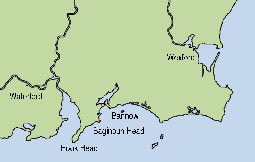
Map showing the location of Baginbun Head where Raymond le Gros landed in 1170 in Ireland. Waterford and Wexford were Norse settlements at that time. The first landing of the Normans took place at Bannow Island in 1169. (This island meanwhile joined the mainland.) |
| ⧼wm-license-information-date⧽ | 2007 |
| ⧼wm-license-information-source⧽ | This map is based on Image:Topography Ireland.jpg and my own work using Gimp and xfig. |
| ⧼wm-license-information-author⧽ | AFBorchert |
ترخيص
|

تاريخ الملف
اضغط على زمن/تاريخ لرؤية الملف كما بدا في هذا الزمن.
| زمن/تاريخ | صورة مصغرة | الأبعاد | مستخدم | تعليق | |
|---|---|---|---|---|---|
| حالي | ★ مراجعة معتمدة 13:22، 8 نوفمبر 2023 | | 825 × 525 (41 كيلوبايت) | Pastakhov (نقاش | مساهمات) | Upload https://upload.wikimedia.org/wikipedia/commons/7/74/Baginbun_Head_Map.png |
لا يمكنك استبدال هذا الملف.
وصلات
لا يوجد صفحات تصل لهذه الصورة.