بيهار
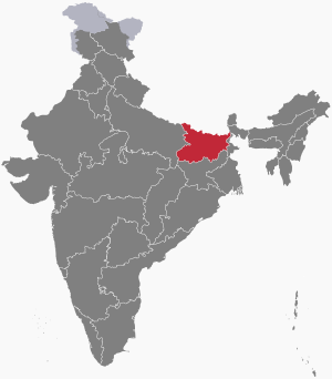
بيهار (بالهندية: बिहार) هي واحدة من ولايات الهند. تقع في الجزء الشرقي من البلاد، وعاصمتها باتنا. تقع شمالها مملكة النيبال. وتحيط بها ولايات الهند الأخرى: أوتار برادش من الغرب، وجهاركاند من الجنوب، وغرب البنغال شرقاً. ثقافياً تعتبر جزء من المنطقة المتحدثة باللغة الهندية في بلاد الهند. بيهار هي أيضاً المكان الذي ولد فيه أول رئيس للهند وهو ريجندرا براساد. عدد سكانها 82878796 نسمة (ثالث أكبر ولايات الهند)، ومساحتها 94164 كم2.
بيهار Bihar مدينة وولاية من ولايات جمهورية الهند الخمس والعشرين، تقع في شمال شرقيها بين ولايات اوتار پرادش وماديا پرادش واوريسة في الغرب والجنوب، والبنغال الغربية في الشرق. وتحدها من الشمال نيبال، مساحتها 173.876 كم2. ويعني اسمها (ديربوذي) بالسنسكريتية. أما مدينة بيهار وتُعرف بـ«بيهار شريف» أيضاً فهي مدينة تقع على رافد للغانج، وكانت عاصمة لأسرة بالا Pala التي حكمت في القرن العاشر الميلادي، وفيها معالم من القرن الخامس الميلادي والكثير من المساجد والأضرحة الإسلامية.
On 15 November 2000, southern Bihar was ceded to form the new state of Jharkhand.[10] Only 11.27% of the population of Bihar lives in urban areas as per a 2020 report.[11] Additionally, almost 58% of Biharis are below the age of 25, giving Bihar the highest proportion of young people of any Indian state.[12] The official language is Hindi and additional official language is Urdu, although other languages are common, including Maithili, Magahi, Bhojpuri, and other Languages of Bihar.
In Ancient and Classical India, the area that is now Bihar was considered the centre of political and cultural power and as a haven of learning.[13] From Magadha arose India's first empire, the Maurya empire, as well as one of the world's most widely adhered-to religions: Buddhism.[14] Magadha empires, notably under the Maurya and Gupta dynasties, unified large parts of South Asia under a central rule.[15] Another region of Bihar, Mithila, was an early centre of learning and the centre of the Videha kingdom.[16][17]
However, since the late 1970s, Bihar has lagged far behind other Indian states in terms of social and economic development.[18] Many economists and social scientists claim that this is a direct result of the policies of the central government, such as the freight equalisation policy,[19][20] its apathy towards Bihar,[21] lack of Bihari sub-nationalism,[22] and the Permanent Settlement of 1793 by the British East India Company.[20] The state government has, however, made significant strides in developing the state.[23] Improved governance has led to an economic revival in the state through increased investment in infrastructure,[24] better healthcare facilities, greater emphasis on education, and a reduction in crime and corruption.[25]
. . . . . . . . . . . . . . . . . . . . . . . . . . . . . . . . . . . . . . . . . . . . . . . . . . . . . . . . . . . . . . . . . . . . . . . . . . . . . . . . . . . . . . . . . . . . . . . . . . . . . . . . . . . . . . . . . . . . . . . . . . . . . . . . . . . . . . . . . . . . . . . . . . . . . . . . . . . . . . . . . . . . . . . .
أصل الاسم
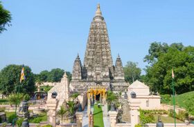
The name Bihar derives from the Sanskrit and Pali word vihāra (Devanagari: विहार), meaning "abode". The region roughly encompassing the present state had many Buddhist vihāras, the abodes of Buddhist monks in the ancient and medieval periods. Medieval writer Minhaj al-Siraj Juzjani records in the Tabaqat-i Nasiri that in 1198 Bakhtiyar Khalji committed a massacre in a town identified with the word, later known as Bihar Sharif, about 70 km (43 mi) away from Bodh Gaya.[26][27]
التاريخ
لبيهار ماض طويل في تاريخ الهند، قامت فيها ممالك من العصر الفيدي الباكر قبل 1500ق.م، كما كانت مركزاً لنشأة حضارات هندية متعاقبة، وجزءاً من ممالك وإمارات إسلامية ظهرت في شمالي الهند حتى احتلالها من قبل الإنكليز، وتسميتها (مقاطعة) عام 1936، ثم (ولاية) عام 1947. وقد كانت بيهار مركزاً للحركات المناهضة للاستعمار البريطاني، ومنها حركة المقاومة السلبية التي قادها غاندي من منطقة شامباران في شمالي الولاية.
بوذية ماگادا قضى عليها تماماً الغزو الإسلامي بقيادة محمد بن بختيار خلجي، الذي دمر العديد من ڤيهارات والجامعات الشهيرة في نالندا و ڤيكرامشيلا، وقـُتـِل الآلالف من الرهبان البوذيين في القرن الثاني عشر.[28] [29]
العصر القديم
Chirand, on the northern bank of the Ganga River, in Saran district, has an archaeological record from the Neolithic age (ح. 2500–1345 BCE).[30][31] Regions of Bihar – such as Magadha, Mithila, and Anga – are mentioned in religious texts and epics of ancient India.
Mithila gained prominence after the establishment of the Videha Kingdom.[32][33] During the late Vedic period (ح. 1100–500 BCE), Videha became one of the major political and cultural centers of South Asia, along with Kuru and Pañcāla. The kings of the Videha Kingdom were called Janakas.[34] Sita, a daughter of one of the Janaks of Mithila is mentioned as the consort of Lord Rama, in the Hindu epic Ramayana, written by Valmiki.[32][35][صفحة مطلوبة] The Videha Kingdom later became incorporated into the Vajjika League which had its capital in the city of Vaishali, which is also in Mithila.[36] Vajji had a republican form of government where the head of state was elected from the rajas. Based on the information found in texts pertaining to Jainism and Buddhism, Vajji was established as a republic by the sixth century BCE, before the birth of Gautama Buddha in 563 BCE, making it the first known republic in India.
The Haryanka dynasty, founded in 684 BCE, ruled Magadha from the city of Rajgriha (modern Rajgir). The two well-known kings from this dynasty were Bimbisara and his son Ajatashatru, who imprisoned his father to ascend the throne. Ajatashatru founded the city of Pataliputra which later became the capital of Magadha. He declared war and conquered the Vajjika League. The Haryanka dynasty was followed by the Shishunaga dynasty. Later, the Nanda Dynasty ruled a vast tract stretching from Bengal to Punjab.
The Nanda dynasty was replaced by the Maurya Empire, India's first empire. The Maurya Empire and the religion of Buddhism arose in the region that now makes up modern Bihar. The Mauryan Empire, which originated from Magadha in 325 BCE, was founded by Chandragupta Maurya, who was born in Magadha. It had its capital at Pataliputra (modern Patna). Mauryan Emperor Ashoka, who was born in Pataliputra (Patna), is often considered to be among the most accomplished rulers in world history.[37][38]
The Gupta Empire, which originated in Magadha in 240 CE, is referred to as the Golden Age of India in science, mathematics, astronomy, commerce, religion, and Indian philosophy.[39] Bihar and Bengal were invaded by Rajendra Chola I of the Chola dynasty in the 11th century.[40][41]
العصر الوسيط
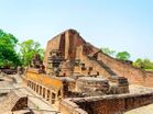
Buddhism in Magadha went into decline due to the invasion of محمد بن بختيار خلجي, during which many of the viharas were destroyed along with the universities of Nalanda and Vikramashila. Some historians believe that thousands of Buddhist monks were massacred during the 12th century.[42][43][44][45] D. N. Jha suggests, instead, that these incidents were the result of Buddhist–Brahmin skirmishes in a fight for supremacy.[46] After the fall of the Pala Empire, the Chero dynasty ruled some parts of Bihar from the 12th century until Mughal rule in the 16th century.[47] In 1540, the great Pathan chieftain, Sher Shah Suri, took northern India from the Mughals and declared Delhi his capital.
From the 11th century to the 20th century, Mithila was ruled by various indigenous dynasties. The first of these were the Karnatas, followed by the Oiniwar dynasty and Raj Darbhanga.[48] It was during this period that the capital of Mithila was shifted to Darbhanga.[49][50]
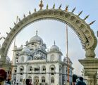
The tenth and the last guru of Sikhism, Guru Gobind Singh, was born in Patna in 1666. With political instability in the Mughal Empire following Aurangzeb's death in 1707, Murshid Quli Khan declared Bengal's independence and named himself نواب البنغال.
عصر الاستعمار
After the Battle of Buxar (1764), the British East India Company obtained the diwani rights (rights to administer and collect tax revenue) for Bihar, Bengal, and Odisha. The rich resources of fertile land, water, and skilled labour had attracted the foreign imperialists, particularly the Dutch and British, in the 18th century. A number of agriculture-based industries had been started in Bihar by foreign entrepreneurs.[51] Bihar remained a part of the Bengal Presidency of British India until 1912, when Bihar and Orissa were carved out as separate provinces.
قبل وبعد الاستقلال
Farmers in Champaran had revolted against indigo cultivation in 1914 (at Pipra) and 1916 (Turkaulia). In April 1917, Mahatma Gandhi visited Champaran, where Raj Kumar Shukla had drawn his attention to the exploitation of the peasants by European indigo planters. The Champaran Satyagraha that followed received support from many Bihari nationalists, such as Rajendra Prasad, Shri Krishna Sinha and Anugrah Narayan Sinha.[52][53]
In the northern and central regions of Bihar, the Kisan Sabha (peasant movement) was an important consequence of the independence movement. It began in 1929 under the leadership of Swami Sahajanand Saraswati who formed the Bihar Provincial Kisan Sabha (BPKS), to mobilise peasant grievances against the zamindari attacks on their occupancy rights. The movement intensified and spread from Bihar across the rest of India, culminating in the formation of the All India Kisan Sabha (AIKS) at the Lucknow session of the Indian National Congress in April 1936, where Saraswati was elected as its first president.[54]
Following independence, Bihari migrant workers have faced violence and prejudice in many parts of India, such as Maharashtra, Punjab, and Assam.[55][56]
. . . . . . . . . . . . . . . . . . . . . . . . . . . . . . . . . . . . . . . . . . . . . . . . . . . . . . . . . . . . . . . . . . . . . . . . . . . . . . . . . . . . . . . . . . . . . . . . . . . . . . . . . . . . . . . . . . . . . . . . . . . . . . . . . . . . . . . . . . . . . . . . . . . . . . . . . . . . . . . . . . . . . . . .
الجغرافيا
تضاريس بيهار لينة تتألف من سهول منبسطة وواطئة، متوسط ارتفاعاتها بحدود 75م فوق سطح البحر، تكونت من اللحقيات والطمي النهري لسهل نهر الگانج وروافده، جنوب سلاسل جبال هيمالايا، وتشغل أراضي الولاية الشمالية والشرقية. أما بقية تضاريسها فهي تلال وهضاب واطئة تشغلها تلال براجماهال ومرتفعات هضبة شوتاناگپور الداخلة في جنوبي وجنوب غربي الولاية وترتفع 200-500م وسطياً.
مناخ بيهار مداري موسمي تظهر فيه ثلاثة فصول هي الفصل الحار (آذار ـ حزيران) والفصل المطير (حزيران ـ تشرين الأول) والفصل البارد (تشرين الثاني ـ شباط). أمطارها السنوية بحدود 1000-1500 مم. والولاية غنية بمصادرها المائية كنهر الگانج الذي يخترق سهولها الشمالية من الغرب نحو الشرق، بروافده الكثيرة التي كثيراً ما تغمر السهول بمياه فيضاناتها.[57]
النبيت والوحيش
Bihar has reserved Forest area of 6,845 km2 (2,643 sq mi), which is 7.27% of its geographical area.[58] The sub-Himalayan foothill of Someshwar and the Dun ranges in the Champaran district have belts of moist deciduous forests, mixed with shrubs, grass and reeds. High rainfall (above 1,600 mm [63 in]) promotes forests of Sal (Shorea robusta) in these areas. Other important trees are Sal Cedrela Toona, Khair, and Semal. Deciduous forests also occur in the Saharsa and Purnia districts,[59] with common trees including Shorea robusta (sal), Diospyros melanoxylon (kendu), Boswellia serrata (salai), Terminalia tomentose (asan), Terminalia bellerica (bahera), Terminalia arjuna (arjun), Pterocarpus marsupium (paisar), and Madhuca indica (mahua).
Valmiki National Park covers about 800 km2 (309 sq mi) of forest and is the 18th Tiger Reserve of India, ranked fourth in terms of density of tiger population.[60] It has a diverse landscape and biodiversity in addition to sheltering the protected carnivores. Vikramshila Gangetic Dolphin Sanctuary in Bhagalpur region is a reserve for the endangered South Asian river dolphin.[58] Other species in Bihar include leopard, bear, hyena, bison, chital and barking deer. Crocodilians including gharials and muggers as well as Gangetic turtles can be found in the river systems. Karkatgarh Waterfall on Karmanasa River is a natural habitat of the crocodilians. In 2016, the government of Bihar has accepted the proposal of the forest authorities to turn the place into a Crocodile Conservation Reserve (CCR).[61] Other notable wildlife sanctuaries include Kaimur Wildlife Sanctuary, Bhimbandh Wildlife Sanctuary and Gautam Buddha Wildlife Sanctuary. Many varieties of local and migratory bird species can be seen in natural wetland of Kanwar Lake Bird Sanctuary, Asia's largest oxbow lake and only Ramsar site in Bihar, and other notable wetlands of Baraila lake, Kusheshwar Nath Lake, Udaypur lake.[58]
الموارد الطبيعية
Bihar is the principal holder of the country's pyrite resources and possesses 95% of the resources.[62]
In May 2022, a gold mine was found in the district of Jamui.[63] It accounts for more than 44% of country's gold reserve, approximately 223 million tons.[64]
السكان
يقدر عدد سكان بيهار بأكثر من 87 مليون نسمة أي ما يعادل 7٪ من مجموع سكان الهند لعام 1995، تصل فيها الكثافة إلى أكثر من 497 نسمة/كم2، ويعيش نحو ثلاثة أرباع السكان في السهول الزراعية ووادي نهر كوسي وفي سهل بيهار الجنوبي، وتتناقص كثافة السكان باتجاه الجنوب، وهم من الهنود والبنغاليين، يتكلمون عدة لغات بلهجات كثيرة، أهمها اللغة البيهارية ـ الهندية والأوردية، والبيهارية وثيقة الصلة بالبنغالية، ويدين نحو 85٪ منهم بالهندوسية والبقية مسلمون.
ديموغرافيا
| نمو السكان | |||
|---|---|---|---|
| Census | Pop. | %± | |
| 1951 | 29٬085٬000 | ||
| 1961 | 34٬841٬000 | 19.8% | |
| 1971 | 42٬126٬000 | 20.9% | |
| 1981 | 52٬303٬000 | 24.2% | |
| 1991 | 64٬531٬000 | 23.4% | |
| 2001 | 82٬999٬000 | 28.6% | |
| Source:Census of India[65] | |||
بيهار هي ثالث ولايات الهند اكتظاظاً بالسكان بتعداد إجمالي 82,998,509 (43,243,795 ذكر و 39,754,714 أنثى).[66][67] نحو 90 بالمائة من سكان بيهار يعيشون في مناطق قروية. ونحو 58 في المائة من البيهاريين هم تحت سن 25 عاماً، وهي أعلى نسبة في الهند. الهندوسية يعتنقها 83.2% من السكان وهي ديانة الأغلبية في الولاية.[68] الإسلام يعتنقه 16.5% من السكان, and other religions less than 0.5%.[68]
أكبر المدن أو البلدات في {{{country}}}
المصدر؟ | |||||||||
|---|---|---|---|---|---|---|---|---|---|
| الترتيب | التعداد | ||||||||
| 1 | [[{{{city_1}}}]] | {{{pop_1}}} | |||||||
| 2 | [[{{{city_2}}}]] | {{{pop_2}}} | |||||||
| 3 | [[{{{city_3}}}]] | {{{pop_3}}} | |||||||
| 4 | [[{{{city_4}}}]] | {{{pop_4}}} | |||||||
| 5 | [[{{{city_5}}}]] | {{{pop_5}}} | |||||||
| 6 | [[{{{city_6}}}]] | {{{pop_6}}} | |||||||
| 7 | [[{{{city_7}}}]] | {{{pop_7}}} | |||||||
| 8 | [[{{{city_8}}}]] | {{{pop_8}}} | |||||||
| 9 | [[{{{city_9}}}]] | {{{pop_9}}} | |||||||
| 10 | [[{{{city_10}}}]] | {{{pop_10}}} | |||||||
. . . . . . . . . . . . . . . . . . . . . . . . . . . . . . . . . . . . . . . . . . . . . . . . . . . . . . . . . . . . . . . . . . . . . . . . . . . . . . . . . . . . . . . . . . . . . . . . . . . . . . . . . . . . . . . . . . . . . . . . . . . . . . . . . . . . . . . . . . . . . . . . . . . . . . . . . . . . . . . . . . . . . . . .
الحكومة والإدارة
| Bihar State Symbols [69] | ||
| طائر الولاية | India roller | |
| حيوان الولاية | گاور | |
| زهرة الولاية | Kanchnar | |
| شجرة الولاية | Peepal | |
| التقسيمات | المقرات | المناطق | ||
| Bhagalpur | Bhagalpur | Banka, Bhagalpur | ||
| Darbhanga | Darbhanga | Begusarai, Darbhanga, Madhubani, Samastipur | ||
| Kosi | Saharsa | Madhepura, Saharsa, Supaul | ||
| Magadh | Gaya | Arwal, Aurangabad, Gaya, Jehanabad, Nawada | ||
| Munger | Munger | Jamui, Khagaria, Munger, Lakhisarai, Sheikhpura | ||
| Patna | باتنا | Bhojpur, Buxar, Kaimur, Patna, Rohtas, Nalanda | ||
| Purnia | Purnea | Araria, Katihar, Kishanganj, Purnia | ||
| Saran | Chapra | Gopalganj, Saran, Siwan | ||
| Tirhut | Muzaffarpur | East Champaran, Muzaffarpur, Sheohar, Sitamarhi, Vaishali, West Champaran |
أكبر المدن
| Rank | City | Population (2011) | Rank | City | Population (2011) | |||
|---|---|---|---|---|---|---|---|---|
| 1 | Patna | 1,684,222 | 11 | Begusarai | 252,008 | |||
| 2 | Gaya | 474,093 | 12 | Katihar | 240,838 | |||
| 3 | Bhagalpur | 400,146 | 13 | Bettiah | 237,254 | |||
| 4 | Muzaffarpur | 354,462 | 14 | Motihari | 221,646 | |||
| 5 | Bihar Sharif | 337,819 | 15 | Saharsa | 216,491 | |||
| 6 | Darbhanga | 296,039 | 16 | Munger | 213,303 | |||
| 7 | Purnia | 282,248 | 17 | Chhapra | 202,352 | |||
| 8 | Sasaram | 264,709 | 18 | Sitamarhi | 67,818 | |||
| 9 | Arrah | 261,430 | 19 | Madhubani | 164,156 | |||
| 10 | Samastipur | 253,136 |
Politics
Politics of Bihar has been based on caste, since Indian independence. The important castes with political presence in Bihar includes: Yadav, Koeri, Kurmi, Rajput, Bhumihar and Brahmin. Before 1990, the politics was dominated by Forward Castes– Brahmin, Rajput, Bhumihar and Kayastha. The numerous Other Backward Class group was only given a token representation in the government. This over representation of upper castes was due to their dominance in the Indian National Congress, which dominated the politics of state for three decades after independence of India. According to political scientist, Sanjay Kumar: "using their dominant role in state's government, in the period before 1990, the Forward Castes deliberately subverted the 'land reforms', which could have helped Backward Castes and the Scheduled Castes". The upper backwards relied on Lok Dal and later Janata Dal political party for increasing their political representation. The year of 1989-90 saw the implementation of Mandal Commission's recommendation by Vishwanath Pratap Singh's government, which reserved 27% per cent seats in government jobs and educational institutions for the members of Other Backward Class. This event mobilised them against the "politics of religion" of Bhartiya Janata Party, which was backed by the Forward Castes. The leaders like Lalu Prasad Yadav and Nitish Kumar took lead in this mobilisation, and by 1990, the upper backwards– Koeri, Kurmi, Yadav became the new political elites of state.[71]
However, the tipping point of this Backward Caste unity came in 1995 Bihar Legislative Assembly election, when the dominant OBC castes, who were at forefront in the collective struggle against the Forward Castes, were divided into two rival political camps. While one of these camps was led by Yadavs under Janata Dal, other camp was led by Koeri and Kurmis, who assembled under Samata Party. According to Sanjay Kumar, this was the election in which the caste divide in the state was witnessed not between the Forward and Backward Castes, but between two groups of Backward Castes itself. It was this election, from which, the Forward Castes felt completely marginalised in Bihar's electoral politics and from then onwards, they didn't remain in a position to play any significant role in state's politics.[72]
By 2004, The Economist magazine said that "Bihar [had] become a byword for the worst of India, of widespread and inescapable poverty, of corrupt politicians indistinguishable from mafia-dons they patronise, caste-ridden social order that has retained the worst feudal cruelties".[73] In 2005, the World Bank believed that issues faced by the state were "enormous" because of "persistent poverty, complex social stratification, unsatisfactory infrastructure and weak governance".[74] اعتبارا من 2023[تحديث] there are two main political formations: the National Democratic Alliance (NDA) which comprises Bharatiya Janata Party (BJP), Rashtriya Lok Janshakti Party (RLJP); and the United Progressive Alliance (UPA) between Rashtriya Janata Dal (RJD), Hindustani Awam Morcha, Rashtriya Lok Samta Party, Janata Dal (United) (JDU) and Indian National Congress (INC). There are many other political formations. The Communist Party of India had a strong presence in Bihar at one time, which has since weakened.[75] The Communist Party of India (Marxist) CPI(M) and CPM and All India Forward Bloc (AIFB) have a minor presence, along with the other extreme leftist parties.[76]
Nitish Kumar has been chief minister of Bihar for 13 years between 2005 and 2020. In contrast to prior governments, which emphasised divisions of caste and religion, his political platform was based on economic development, reduction of crime and corruption, and greater social equality. Since 2010, the government confiscated the properties of corrupt officials and redeployed them as school buildings.[77] They also introduced Bihar Special Court Act to curb crime.[78] It also legislated a two-hour lunch break on Fridays, to enable Muslim employees to pray and thereby reduce absenteeism.[79] The government has prohibited the sale and consumption of alcohol in the state since March 2016,[80] which has been linked to a drop in tourism[81] and a rise in substance abuse.[82]
الاقتصاد
تعد بيهار إحدى الولايات الريفية في الهند. ترتفع فيها نسبة الريفيين والعاملين في القطاع الاقتصادي الأول إلى 85٪ من السكان تقريباً، يعيشون في قرى وبلدات منتشرة في كل مكان تقريباً، يعملون في الزراعة وتربية الحيوانات. أما مدن بيهار فأكبرها مدينة باتنه Patna عاصمة الولاية وسكانها نحو مليون نسمة، ثم مدن بهاغالبور ورانشي وغايا وبوكارو وجمشيدپور. وتنتقل عاصمة الولاية إلى رانشي في الفصل الحار.
تنتج بيهار الكثير من المحصولات الزراعية أهمها الأرز والذرة والقمح والشعير والخضراوات والمحاصيل الصناعية مثل قصب السكر والتبغ. كما تسهم بنحو 40٪ من إنتاج الهند من المعادن والثروات الباطنية. أهمها النحاس والحديد والبوكسيت والفوسفات والكايينيت وغيرها. وتقوم في الولاية صناعات كثيرة منها صناعة الحديد والأسمدة والإسمنت والزجاج وتجهيزات الآلات والحرير والجوت، وكذلك الصناعات الغذائية والبتروكيمياوية التي تعتمد النفط المنتج في ولاية أسام.
معرض الصور
Photo Gallery
|
|---|
|
المصادر
- ^ خطأ استشهاد: وسم
<ref>غير صحيح؛ لا نص تم توفيره للمراجع المسماةBiharCensus2023 - ^ ""Happy To Work...": Rajendra Arlekar On New Role Of Bihar Governor". NDTV. PTI. 12 February 2023. Retrieved 12 February 2023.
- ^ "State Profile". Government of Bihar. Archived from the original on 22 September 2017. Retrieved 27 September 2017.
- ^ "Bihar Location - Geographical Location Bihar India". www.bharatonline.com. Retrieved 24 March 2023.
- ^ Mandal, R. B. (2010). Wetlands Management in North Bihar (in الإنجليزية). Concept Publishing Company. ISBN 978-81-8069-707-4.
- ^ "Bihar Profile" (PDF). census.gov.in. Archived from the original (PDF) on 9 August 2021. Retrieved 14 March 2020.
- ^ "Bihar GDP" (PDF). prsindia.org. Retrieved 28 February 2023.
- ^ "Sub-national HDI – Area Database". Global Data Lab (in الإنجليزية). Institute for Management Research, Radboud University. Archived from the original on 23 September 2018. Retrieved 3 July 2021.
- ^ "Sex ratio of State and Union Territories of India as per National Health survey Phase I (2019-2020)" (PDF). Ministry of Health and Family Welfare, India. 10 December 2020.
- ^ Dutt, Ashok K. "Jharkhand". Encyclopædia Britannica. Archived from the original on 8 March 2012. Retrieved 18 July 2010.
- ^ Subhash, Pathak (26 December 2020). "Bihar cabinet approves 111 new urban bodies, 5 more municipal corporations". Hindustan Times. Retrieved 25 November 2022.
- ^ Guruswamy, Mohan; Kaul, Abhishek (15 December 2003). "The Economic Strangulation of Bihar" (PDF). New Delhi, India: Centre for Policy Alternatives. p. 2. Archived from the original (PDF) on 30 May 2009. Retrieved 17 August 2015.
- ^ Bihar, Past & Present: souvenir, 13th Annual Congress of Epigraphica by P. N. Ojha, Kashi Prasad Jayaswal Research Institute
- ^ Mishra Pankaj, The Problem, Seminar 450 – February 1997
- ^ "The History of Bihar". Bihar Government. Archived from the original on 31 مارس 2014. Retrieved 15 أغسطس 2008.
- ^ Mandal, R. B. (2010). Wetlands Management in North Bihar. Concept Publishing Company. p. 87. ISBN 9788180697074. Retrieved 8 February 2017.
- ^ Kumāra, Braja Bihārī (1998). Small States Syndrome in India. Concept Publishing Company. p. 146. ISBN 9788170226918. Retrieved 16 February 2017.
- ^
- "Bihar's 'first' Economic Survey Report tabled". The Times of India. 7 مارس 2007. Archived from the original on 18 مايو 2013. Retrieved 22 أغسطس 2008.
- Bal Thackeray (5 مارس 2008). "Biharis an unwanted lot". The Times of India. Archived from the original on 10 مارس 2008. Retrieved 5 مارس 2008.
- Wajihuddin, Mohammed (10 أغسطس 2008). "'Bihari' has become an abuse". The Times of India. Archived from the original on 5 مايو 2013. Retrieved 10 أغسطس 2008.
- ^ Das, Arvind N. (1992). The Republic of Bihar. New Delhi: Penguin Books. ISBN 978-0-14-012351-7.
- ^ أ ب Goswami, Urmi A (16 February 2005). "'Bihar Needs an Icon, a person who stands above his caste' (Dr Shaibal Gupta – Rediff Interview)". Rediff. Archived from the original on 20 February 2005. Retrieved 16 February 2005.
- ^
- Guruswamy, Mohan; Baitha, Ramnis Attar; Mohanty, Jeevan Prakash (15 June 2004). "Centrally Planned Inequality: The Tale of Two States – Punjab and Bihar" (PDF). New Delhi, India: Centre for Policy Alternatives. Archived from the original (PDF) on 26 March 2009. Retrieved 17 August 2015.
- Guruswamy, Mohan; Mohanty, Jeevan Prakash (15 February 2004). "The De-urbanisation of Bihar" (PDF). New Delhi, India: Centre for Policy Alternatives. Archived from the original (PDF) on 26 March 2009. Retrieved 17 August 2015.
- ^
- Ahmed Farzand and Mishra Subhash, Leaders of Bihar unite to counter Raj Thackeray, India Today, 31 October 2008
- Gupta, Shaibal. "Bihar: Identity and Development". Asian Development Research Institute, Patna. Archived from the original on 30 March 2005. Retrieved 30 April 2006.
- ^ Phadnis, Aditi (26 July 2008). "Lalu in the red". Business Standard. Archived from the original on 7 June 2011. Retrieved 22 August 2015.
- ^ Goswami, Urmi A (17 يونيو 2008). "Biharis get work at home, bashers realise their worth". The Economic Times. India. Archived from the original on 13 فبراير 2009. Retrieved 17 يونيو 2008.
- ^
- Dharma, Supriya; Jha, Abhay Mohan (15 July 2008). "Bihar witnesses a quiet transformation". NDTV. Archived from the original on 18 July 2008. Retrieved 22 August 2015.
- Jha, Abhay Mohan (8 March 2008). "English makes inroads in Bihar villages". NDTV. Archived from the original on 9 March 2008. Retrieved 8 March 2008.
- ^ Minhaj writes that the inhabitants were 100,000 Brahmins.--Bodh Gaya; by Frederick M. Asher; p. 14
- ^ Kartar Singh Duggal The Sikh Gurus: their lives and teachings; p. 4; with shaven heads.[مطلوب توضيح]
- ^ Gopal Ram, Rule Hindu Culture During and After Muslim, pp. 20, "Some invaders, like Bakhtiar Khilji, who did not know the value of books and art objects, destroyed them in large numbers and also the famous Nalanda ..."
- ^ The Maha-Bodhi By Maha Bodhi Society, Calcutta (page 8)
- ^ "BIHAR: A QUICK GUIDE TO SARAN". Outlook. Archived from the original on 23 March 2017. Retrieved 24 March 2017.
- ^ "Oldest hamlet faces extinction threat". The Telegraph. Archived from the original on 23 March 2017. Retrieved 24 March 2017.
- ^ أ ب "State Profile". gov.bih.nic.in. Archived from the original on 22 September 2017. Retrieved 26 October 2017.
- ^ Michael Witzel (1989), Tracing the Vedic dialects in Dialectes dans les litteratures Indo-Aryennes ed. Caillat, Paris, pages 13, 17 116–124, 141–143
- ^ Michael Witzel (1989), Tracing the Vedic dialects in Dialectes dans les litteratures Indo-Aryennes ed. Caillat, Paris, pages 13, 141–143
- ^ Michael Witzel (1989), Tracing the Vedic dialects in Dialectes dans les litteratures Indo-Aryennes ed. Caillat, Paris
- ^ Raychaudhuri Hemchandra (1972), Political History of Ancient India, Calcutta: University of Calcutta, pp. 85–86
- ^ Panth, Rabindra (2007). India's Perception Through Chinese Travellers. Nava Nalanda Mahavihara. p. 61. ISBN 9788188242122. Archived from the original on 12 November 2015. Retrieved 6 March 2015.
- ^ A Record of Buddhistic Kingdoms, by Fa-hsien (chapter27)
- ^ "The Gupta Period of India". Ushistory.org. Archived from the original on 2 October 2013. Retrieved 19 November 2013.
- ^ Ali, A. Yusuf (1925). The Making of India. A. & C. Black. p. 60.
- ^ The Cambridge Shorter History of India, p. 145
- ^ The Maha-Bodhi By Maha Bodhi Society, Calcutta (page 8)
- ^ Smith V. A., Early history of India
- ^ Elliot, History of India, Vol 4
- ^ Scott, David (May 1995). "Buddhism and Islam: Past to Present Encounters and Interfaith Lessons". Numen. 42 (2): 141–155. doi:10.1163/1568527952598657. JSTOR 3270172.
- ^ Jha, D. N. (9 July 2014). "Grist to the reactionary mill". The Indian Express. Archived from the original on 3 February 2015. Retrieved 3 February 2015.
- ^ Singh, Pradyuman (19 January 2021). Bihar General Knowledge Digest. Prabhat Prakashan. ISBN 9789352667697.
- ^ Jha, Makhan (1997). Anthropology of Ancient Hindu Kingdoms: A Study in Civilizational Perspective. M.D. Publications Pvt. ISBN 9788175330344. Retrieved 11 December 2016.
- ^ Mandal, R. B. (2010). Wetlands management in North Bihar. Concept Publishing Company. ISBN 9788180697074. Retrieved 14 December 2016.
- ^ Jha, Makhan (1997). Anthropology of Ancient Hindu Kingdoms: A Study in Civilizational Perspective. M.D. Publications Pvt. ISBN 9788175330344. Retrieved 14 December 2016.
- ^ "Early Agro based Industries". Bihargatha. 2011. Archived from the original on 10 September 2011. Retrieved 13 August 2015.
- ^ Brown, Judith Margaret (1972). Gandhi's Rise to Power, Indian Politics 1915–1922: Indian Politics 1915–1922. New Delhi: Cambridge University Press Archive. p. 77. ISBN 978-0-521-09873-1. Archived from the original on 10 May 2018. Retrieved 19 April 2018.
- ^ "Eminent Gandhian Dr A N Sinha, First Bihar Deputy CM cum Finance Minister". Indian Post. Archived from the original on 2 December 2008. Retrieved 20 May 2008.
- ^ Bandyopādhyāya, Śekhara (2004). From Plassey to Partition: A History of Modern India. Orient Longman. pp. 406–407. ISBN 978-81-250-2596-2.
- ^ Kumod Verma (14 فبراير 2008). "Scared Biharis arrive from Mumbai". The Times of India. Archived from the original on 22 أكتوبر 2012. Retrieved 14 فبراير 2008.
- ^ Hussain, Wasbir (11 أغسطس 2007). "30 Killed in Northeast Violence in India". Washington Post. Archived from the original on 7 نوفمبر 2012. Retrieved 25 فبراير 2006.
- ^ أ ب عادل عبد السلام. "بيهار". الموسوعة العربية. Retrieved 2009-04-05.
- ^ أ ب ت "पर्यावरण एवं वन विभाग". forest.bih.nic.in. Retrieved 31 August 2019.
- ^ "Forest in Bihar". Forest Ministry of Bihar. Archived from the original on 10 أبريل 2009. Retrieved 28 نوفمبر 2008.
- ^ "VALMIKI". 27 May 2004. Archived from the original on 27 May 2004. Retrieved 26 October 2017.
- ^ Mishra, Prasun K (6 January 2019). "Bihar's first crocodile conservation reserve near Karkatgarh soon". Hindustan Times (in الإنجليزية). Retrieved 1 October 2019.
- ^ Mishra, B. K. (20 October 2021). "Mineral exploration to boost Bihar's economy: Janak Ram". The Times of India. Retrieved 31 May 2022.
- ^ Saha, Pritam (29 May 2022). "'Ants' give whereabouts of 230 MM tons gold mine in Jamui! Bihar on lookout". Zee News. Retrieved 29 May 2022.
- ^ PTI (28 May 2022). "Bihar govt allows exploration of 'country's largest' gold reserve". Business Standard. Retrieved 31 May 2022.
- ^ "Census Population" (PDF). Census of India. Ministry of Finance India. Retrieved 2008-12-18.
- ^ Total population of Bihar
- ^ "census of india". Census of India 2001. Government of India. 27 May 2002. Retrieved 2007-04-14.
{{cite web}}: Check date values in:|date=(help) - ^ أ ب التعداد الهندي
- ^ Bihar - Land, People, Festival, Arts, Tourism, Economy
- ^ "LIST OF URBAN LOCAL BODY Bihar" (PDF).
- ^ Sanjay Kumar (2018). Post-Mandal Politics in Bihar: Changing Electoral Patterns. SAGE Publishing India. pp. 27–28. ISBN 978-9352805860. Retrieved 22 January 2021.
- ^ Kumar, Sanjay (1999). ""New Phase in Backward Caste Politics in Bihar: Janata Dal on the Decline."". Economic and Political Weekly. 34 (34/35): 2472–80. JSTOR 4408343.
The polarisation was not on the lines of the upper and the backward caste divide, but it was around the two axes of backward caste politics. Laloo Yadav after comp- leting his term in office even with a minority government went to polls in a situation where an anti-incumbency wave was sweeping the country. The consolidated backward castes had fragmented into two blocs, one represented by the yadavs in the form of the Janata Dal and the other represented by the kurmis and koeris represented by the Samata Party. For the first time, the upper-castes felt totally marginalised in the state's politics since the support base of their natural ally, the Congress, has been completely eroded. while the BJP was unable to make much inroads among the voters.
- ^ "Bihar a byword for worst of India: The Economist". The Indian Express. Press Trust of India. 25 February 2004. Archived from the original on 10 October 2012. Retrieved 9 September 2019.
- ^ "Bihar – Towards a Development Strategy" (PDF). Washington, DC: World Bank. 2005. Archived (PDF) from the original on 22 March 2019. Retrieved 22 March 2019.
- ^ "State Wise Seat Won & Valid Votes Polled by Political Parties" (PDF). Election Commission of India. Archived (PDF) from the original on 24 April 2015. Retrieved 20 September 2015.
- ^ "The Decline of Communist Mass Base in Bihar: Jagannath Sardar". 25 سبتمبر 2011. Archived from the original on 6 يناير 2016. Retrieved 20 سبتمبر 2015.
- ^ "Nitish Kumar government orders corrupt official's home to be made into school". Archived from the original on 4 May 2015. Retrieved 27 February 2015.
- ^ "Court upholds Bihar Special Court Act". Archived from the original on 5 January 2012. Retrieved 27 February 2015.
- ^ "Bihar fixes time for Friday prayers by its employees". The Indian Express. 25 يوليو 2012. Archived from the original on 20 فبراير 2013. Retrieved 25 يوليو 2012.
- ^ "Bihar Brings New Law on Alcohol Ban After HC Quashed Old One". The Wire. PTI. 4 October 2016. Archived from the original on 9 January 2017. Retrieved 3 January 2017.
- ^ "Bihar witnesses serious drop in tourism after liquor ban". Pradesh18. 3 September 2016. Archived from the original on 2 December 2016. Retrieved 3 January 2017.
- ^ Chaudhary, Amit Kumar; Jha, Sujeet; Mishra, Himanshu (1 June 2017). "Udta Bihar: Huge spike in substance abuse, alcohol bootlegging year after ban". India Today (in الإنجليزية). Retrieved 14 January 2020.
وصلات خارجية
- الحكومة
- General information
- Bihar Encyclopædia Britannica entry
- Bihar at the Open Directory Project
- Geographic data related to بيهار at OpenStreetMap
