ساموتراقيا
ساموتراقيا ( Samothrace وتـُعرف أيضاً بإسم Samothraki؛ باليونانية: Σαμοθράκη، [samoˈθraci]) هي جزيرة يونانية في شمال بحر إيجة. It is a municipality within the Evros regional unit of Thrace. The island is 17 km (11 mi) long and is 178 km2 (69 sq mi) in size and has a population of 2,596 (2021 census).[3] Its main industries are fishing and tourism. Resources on the island include granite and basalt. Samothrace is one of the most rugged Greek islands, with Mt. Saos and its highest peak Fengari rising to 1,611 m (5,285 ft). The Winged Victory of Samothrace, which is now displayed at the Louvre in Paris, originates from the island.
ساموتراقيا Samothrace
Σαμοθράκη | |
|---|---|
 View of the Chora (Samothraki) | |
 ساموتراقيا Samothrace الموقع في المنطقة  | |
| الإحداثيات: 40°27′00″N 25°35′15″E / 40.45000°N 25.58750°ECoordinates: 40°27′00″N 25°35′15″E / 40.45000°N 25.58750°E | |
| البلد | |
| المنطقة الادارية | East Macedonia and Thrace |
| الوحدة المحلية | Evros |
| الحكومة | |
| • العمدة | Vitsas Athanasios[1] (منذ September 1, 2014[1]) |
| المساحة | |
| • البلدية | 178٫0 كم² (68٫7 ميل²) |
| أعلى منسوب | 1٬611 m (5٬285 ft) |
| أوطى منسوب | 0 m (0 ft) |
| التعداد (2011)[2] | |
| • البلدية | 2٬859 |
| • كثافة البلدية | 16/km2 (42/sq mi) |
| صفة المواطن | Samothracian |
| منطقة التوقيت | UTC+2 (EET) |
| • الصيف (التوقيت الصيفي) | UTC+3 (EEST) |
| Postal code | 680 02 |
| مفتاح الهاتف | 25510 |
| Vehicle registration | ΕΒ |
| الموقع الإلكتروني | www.samothraki.gr |

. . . . . . . . . . . . . . . . . . . . . . . . . . . . . . . . . . . . . . . . . . . . . . . . . . . . . . . . . . . . . . . . . . . . . . . . . . . . . . . . . . . . . . . . . . . . . . . . . . . . . . . . . . . . . . . . . . . . . . . . . . . . . . . . . . . . . . . . . . . . . . . . . . . . . . . . . . . . . . . . . . . . . . . .
التاريخ
القِدم


Samothrace was not a state of any political significance in ancient Greece, since it lacks natural harbours, and most of the island is too mountainous for cultivation: Mount Fengari (literally 'Mt. Moon') rises to 1,611 m (5,285 ft). It was, however, the home of the Sanctuary of the Great Gods, site of important Hellenic and pre-Hellenic religious ceremonies. Among those who visited this shrine to be initiated into the island cult were Lysander of Sparta, Philip II of Macedon and Lucius Calpurnius Piso Caesoninus, father-in-law of Julius Caesar.
The ancient city, the ruins of which are called Palaeopolis ("old city"), was situated on the north coast. Considerable remains still exist of the ancient walls, which were built in massive Cyclopean style, as well as of the Sanctuary of the Great Gods, where mysterious rites (Samothracian Mysteries)[4] took place which were open to both slaves and free people (similar to the Eleusinian Mysteries). Demetrios of Skepsis mentions the Samothracian Mysteries;[4] as does Aristophanes in his Peace.[5]
The traditional account from antiquity is that Samothrace was first inhabited by Pelasgians and Carians, and later Thracians. At the end of the 8th century BC the island was colonised by Greeks from Samos, from which the name Samos of Thrace, that later became Samothrace; however, Strabo denies this. The archaeological evidence suggests that Greek settlement was in the sixth century BC.
The Persians occupied Samothrace in 508 BC, it later passed under Athenian control, and was a member of the Delian League in the 5th century BC. It was subjugated by Philip II, and from then till 168 BC it was under Macedonian suzerainty. With the battle of Pydna Samothrace became independent, a condition that ended when Vespasian absorbed the island in the Roman Empire in AD 70.
During the Roman and particularly the imperial period, thanks to the interest of the Roman emperors, the radiation of the sanctuary of the Great Gods surpassed Greek borders and Samothrace became an international religious center, where pilgrims flocked from all over the Roman world. Apart from the famous sanctuary, also playing a decisive role in the great development of Samothrace were her two ports, situated on the sea road from Troas to Macedonia. Furthermore, an important role was played by her possessions in Perea, which were conceded by the Romans at least during the imperial period, as evidenced by inscriptions of the 1st AD century.[6]
The Book of Acts in the Christian Bible records that the Apostle Paul, on his second missionary journey outside of Palestine, sailed from Troas to Samothrace and spent one night there on his way to Macedonia.[7] The island is mentioned in the King James Version of the Bible, with the name Samothracia.[8]
العصور الوسطى إلى العصر الحديث

St. Theophanes died in Samothrace in 818. The Byzantines ruled until 1204, when Venetians took their place, only to be dislodged by a Genoese family in 1355, the Gattilusi. The Ottoman Empire conquered it in 1457 and it was called Semadirek in Turkish. In the era of Kanuni Sultan Süleyman the Island became a vakıf for the Süleymaniye Mosque and its Imaret in İstanbul. During the Ottoman period, it was one of the islands open to settlement among the Boğazönü Islands. The appearance of a person coming from Samothrace among the new inhabitants of the island of Lemnos in 1490 indicates that the population movements on the island were mostly with the surrounding islands and therefore the coastal areas close to Anatolia. The total tax population of the island in 1519 was 182 soldiers (male population of fighting age). 53 of them were newcomers to the island. There was a total tax population of 220 soldiers here in 1530 (twelve of whom were foreigners). In 1569, there were a total of 4 settlements and a tax population of 742 soldiers on the island. 7 soldiers of this population were Muslims. The fact that neighborhoods, which are the main features of Ottoman towns and cities, were established in this last date indicates the process of becoming a town.[9] However, in the mid-17th century, Bernard Randolph, while describing the island with Thasos and Imbros, states that all three of the Islands were neglected because they were flooded by pirates, and there were only two or three villages in each of them.[10] According to Charles Vellay a rebellion against the Ottoman Rule and Muslim Population by the local population during the Greek War of Independence (1821–1831) led to the massacre of 1,000 inhabitants.[11] The island came under Greek rule in 1913 following the Balkan Wars. It was occupied temporarily by Bulgaria during the Second World War, from 1941 to 1944.
اليوم
The modern port town of Kamariotissa is on the north-west coast and provides ferry access to and from points in northern Greece such as Alexandroupoli and Myrina. There is no commercial airport on the island. Other sites of interest on the island include the ruins of Genoese forts, the picturesque Chora (literally village) and Paleapolis (literally Old Town), and several waterfalls.
A 2019 article estimated that the current population of goats on the island outnumbers humans by about 15 to 1, resulting in unwanted erosion as a result of overgrazing.[12]
المعالم
The island's most famous site is the Sanctuary of the Great Gods (Greek: Hieron ton Megalon Theon). The most famous artifact from the temple complex is the 2.5-metre marble statue of Nike (now known as the Winged Victory of Samothrace), which dates from about 190 BC. It was discovered in pieces on the island in 1863 by the French archaeologist Charles Champoiseau. It is now headless and is displayed at the Louvre in Paris. The Winged Victory is featured on the island's municipal seal.
التجمعات

- Alonia (pop. 291 in 2011)
- Ano Karyotes (22)
- Ano Meria (57)
- Dafnes (16)
- Kamariotissa (1,069)
- Kato Karyotes (41)
- Katsampas (15)
- Lakkoma (317)
- Makrylies (12)
- Palaiopoli (36)
- Potamia (6)
- Profitis Ilias (189)
- Samothrace/Samothraki (Chora) (653)
- Therma (106)
- Xiropotamos (29)
المقاطعة
The province of Samothrace (باليونانية: Επαρχία Σαμοθράκης) was one of the provinces of the Evros Prefecture. It had the same territory as the present municipality.[13] It was abolished in 2006.
. . . . . . . . . . . . . . . . . . . . . . . . . . . . . . . . . . . . . . . . . . . . . . . . . . . . . . . . . . . . . . . . . . . . . . . . . . . . . . . . . . . . . . . . . . . . . . . . . . . . . . . . . . . . . . . . . . . . . . . . . . . . . . . . . . . . . . . . . . . . . . . . . . . . . . . . . . . . . . . . . . . . . . . .
المناخ
Samothraki has a hot-summer Mediterranean climate. Winters are cool and rainy with occasional heavy snowstorms, especially at higher elevations.
| بيانات مناخ قرية كاماريوتيسا (90م) | |||||||||||||
|---|---|---|---|---|---|---|---|---|---|---|---|---|---|
| الشهر | يناير | فبراير | مارس | أبريل | مايو | يونيو | يوليو | أغسطس | سبتمبر | اكتوبر | نوفمبر | ديسمبر | العام |
| العظمى المتوسطة °س (°ف) | 11.5 (52.7) |
12.7 (54.9) |
14.5 (58.1) |
17.2 (63) |
23.7 (74.7) |
28.7 (83.7) |
31.9 (89.4) |
32.3 (90.1) |
27.6 (81.7) |
22.2 (72) |
17.8 (64) |
13.9 (57) |
21٫17 (70٫1) |
| الصغرى المتوسطة °س (°ف) | 6.8 (44.2) |
7.1 (44.8) |
8.6 (47.5) |
10.5 (50.9) |
15.8 (60.4) |
20.5 (68.9) |
23.4 (74.1) |
23.9 (75) |
20.4 (68.7) |
15.8 (60.4) |
12.7 (54.9) |
9.4 (48.9) |
14٫58 (58٫24) |
| هطول mm (inches) | 110.1 (4.335) |
55.1 (2.169) |
73.7 (2.902) |
34.7 (1.366) |
29.7 (1.169) |
15.9 (0.626) |
12.2 (0.48) |
9 (0.35) |
8.4 (0.331) |
74.3 (2.925) |
108.3 (4.264) |
101.7 (4.004) |
633٫1 (24٫925) |
| Source: http://penteli.meteo.gr/stations/samothraki/ (2019-2021 averages) | |||||||||||||
التعداد التاريخي
| السنة | تعداد الجزيرة |
|---|---|
| 1981 | 2,871 |
| 1991 | 3,083 |
| 2001 | 2,723 |
| 2011 | 2,859 |
أشخاص
- Aristarchus of Samothrace (ح. 220), ancient Greek grammarian and Homeric scholar
- Theophanes the Confessor (ح. 758)
- Nikolaos Fardys (1853–1901), Greek scholar
المعرض

Fonias waterfall

Flowing river on the slopes of Mount Fengari
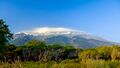
Mount Fengari (Saos)
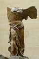
The Winged Victory of Samothrace, one of the best-known ancient Greek statues (Louvre)
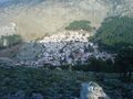
Chora (Samothraki)

Venetian towers

Flag of the revolutionaries of Samothrace during the Greek War of Independence
The Holocaust of Samothraki (1821) by François-Auguste Vinson


.svg)

انظر أيضاً
المراجع
- ^ أ ب "Βιογραφικό Δημάρχου – ΔΗΜΟΣ ΣΑΜΟΘΡΑΚΗΣ". Archived from the original on 2017-12-09. Retrieved 2017-12-08.
- ^ أ ب ت "Απογραφή Πληθυσμού - Κατοικιών 2011. ΜΟΝΙΜΟΣ Πληθυσμός" (in اليونانية). Hellenic Statistical Authority.
- ^ "Απογραφή Πληθυσμού - Κατοικιών 2021. ΜΟΝΙΜΟΣ Πληθυσμός". Hellenic Statistical Authority.
- ^ أ ب Initiation into the Mysteries of the Ancient World, p. 37, في كتب گوگل
- ^ Aristophanes. Peace, line 277
- ^ D. C. Samsaris, Historical Geography of Western Thrace during the Roman Antiquity (in Greek), Thessaloniki 2005, p. 120–126
- ^ Acts 16:11
- ^ "Acts 16:11 - King James Version". Bible Gateway (in الإنجليزية). Archived from the original on 2022-12-04. Retrieved 2022-12-04.
- ^ "SEMADİREK". TDV İslâm Ansiklopedisi (in التركية). Archived from the original on 2022-11-10. Retrieved 2022-11-10.
- ^ Randolph, Bernard (1687). "The Present State of the Islands in the Archipelago". قاموس أكسفورد للسيَر الوطنية (online ed.). Oxford, England: Theater. p. 42. doi:10.1093/ref:odnb/23114. (Subscription or UK public library membership مطلوبة.)
- ^ Charles Vellay, L'irrédentisme hellénique, 1913, 329 pages. page 131: [1] Archived 2023-02-01 at the Wayback Machine
- ^ Associated Press (October 7, 2019). "Tens of thousands of goats munch island into crisis". Morning Ag Clips (in الإنجليزية الأمريكية). Archived from the original on 2019-10-18. Retrieved 2019-10-18.
- ^ "Detailed census results 1991" (PDF). Archived (PDF) from the original on 2016-03-03. Retrieved 2012-09-19. (39 MB) (in Greek and فرنسية)
وصلات خارجية
![]() ساموتراقيا travel guide from Wikivoyage
ساموتراقيا travel guide from Wikivoyage
- Official Samothrace webpage (in Greek)
- Samothraki Visitor Information Website (in English)